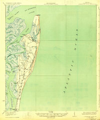
1930 Map of Cumberland Island
USGS Topo · Published 1930This historical map portrays the area of Cumberland Island in 1930, primarily covering Camden County as well as portions of Glynn County. Featuring a scale of 1:62500, this map provides a highly detailed snapshot of the terrain, roads, buildings, counties, and historical landmarks in the Cumberland Island region at the time. Published in 1930, it is one of 3 known editions of this map due to revisions or reprints.
Find a feature on this map
38 named features on this map. Tap any name to fly to it.
Don’t see what you’re looking for? This feature index may not catch every label — zoom into the map to look around manually.
Map Details
Editions of this 1930 Cumberland Island Map
3 editions found
Historical Maps of Camden County Through Time
28 maps found

1917 Boulogne
Camden County, GA

1918 Cumberland Island
Camden County, GA

1919 Boulogne
Camden County, GA

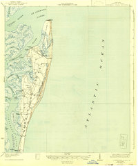
1930 Cumberland Island
Camden County, GA

1945 Cumberland Island
Camden County, GA

1958 Cumberland Island North
Camden County, GA

1958 Cumberland Island South
Camden County, GA

1958 Harrietts Bluff
Camden County, GA

1958 Kingsland NE
Camden County, GA

1961 Dover Bluff
Camden County, GA

1975 Tarboro
Camden County, GA

1978 Jerusalem
Camden County, GA

1978 Tarboro
Camden County, GA

1979 Cumberland Island North
Camden County, GA

1979 Cumberland Island South
Camden County, GA

1979 Dover Bluff
Camden County, GA

1979 Kingsland NE
Camden County, GA

1979 St Marys
Camden County, GA

1980 Harrietts Bluff
Camden County, GA

1993 Cumberland Island North
Camden County, GA

1993 Dover Bluff
Camden County, GA

1993 Jerusalem
Camden County, GA

1993 Kingsland NE
Camden County, GA

1993 St Marys
Camden County, GA

1993 Tarboro
Camden County, GA

1994 Cumberland Island South
Camden County, GA

1994 Harrietts Bluff
Camden County, GA

1998 Cumberland Island North
Camden County, GA