1970s Maps of Candler County, Georgia
Explore 11 historic maps of Candler County from the 1970s. These maps offer a rare glimpse into what life looked like during the 1970s — showing old roads, neighborhoods, homes, and landmarks that have changed or disappeared over time.
Whether you're researching your family's past, planning a metal detecting trip, or studying how Candler County's landscape evolved across the 1970s, these high-resolution maps are a powerful tool for exploring the history of this region.
- Focus on a specific era: All maps on this page are from the 1970s, giving you a focused view of this time period.
- See what’s changed: Compare century-old streets, trails, and buildings to today's modern landscape using overlays and satellite layers.
- Research with precision: Use these maps for genealogy, historical research, land use analysis, or educational projects.
- View, download, or print: Maps are fully viewable online in high resolution, and can be downloaded or printed for your own records.
Start exploring Candler County's history through authentic maps from the 1970s. This is your window into the past.
Candler County, GA maps
(11)- 1970 Map of Cobbtown, 1973 Print
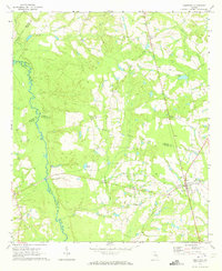 1970 Cobbtown1973 Print · USGSSoutheast Georgia in the early seventies reveals a landscape of tight-knit rural communities and river-bottom lands. Genealogists can trace family roots at Sunlight Cem and Old Reedy Creek Cem, or locate landmarks like Aline and Cobbtown.2 unique versions available
 - 1970 Map of Metter, 1973 Print
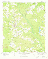
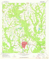 1970 Metter1973 Print · USGSInland Georgia in the early seventies centers on the growing city of Metter and its connection to the Central of Georgia railroad. Researchers can trace rural lineages through family landmarks like Olliff Cem and Rosemary Ch, or locate local hubs like the Drive-in Theater.2 unique versions available
 - 1970 Map of Metter SE, 1973 Print
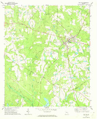
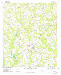
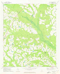 1970 Metter SE1973 Print · USGSCandler County in the early seventies is a landscape of winding river bottoms and rural congregations. Genealogists and local historians can trace the foundations of the community through landmarks like Primitive Grove Ch, Everitt Cem, and Metter Airport.2 unique versions available
 - 1970 Map of Oak Park, 1973 Print
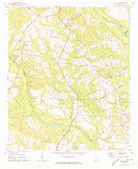 1970 Oak Park1973 Print · USGSEmanuel County at the start of the 1970s reveals a landscape of tight-knit rural communities and pine-lined wetlands. Genealogists and local historians can trace family roots through a high density of sites like Morris Cem, White Chapel, and the settlement at Normantown.2 unique versions available
 - 1971 Map of Stillmore, 1973 Print
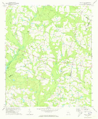
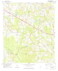
 1971 Stillmore1973 Print · USGSStillmore was a junction of river and rail at the start of the 1970s, positioned right on the Emanuel and Candler county line. Researchers can trace the path of the Old Railroad Grade or locate family burial sites at Oak Grove Cem and Old Beulah Cem.2 unique versions available
 - 1971 Map of Twin City, 1973 Print
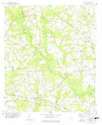
 1971 Twin City1973 Print · USGSThe Emanuel County interior is captured here in the early seventies, centered on the growing community of Twin City. Researchers can trace the legacy of rural life through family-linked sites like Rountree Grove Ch, an Old Railroad Grade, and the County Institute.
 - 1971 Map of Twin City SE, 1973 Print
 1971 Twin City SE1973 Print · USGSEastern Emanuel County in the early seventies is a landscape of winding creek branches and rural congregations. Trace local family history through numerous landmarks like New Beulah Ch, Watson Pond, and the Old Railroad Grade.2 unique versions available
 - 1978 Map of Pulaski
 1978 Pulaski1978 Print · USGSThe rural landscape of Pulaski and the Bulloch-Candler county line are captured here in the late seventies. Genealogists and local historians can trace the Central of Georgia rail line and locate landmarks like Fish Trap Ch, Brannen Cem, and Cypress Lake.
 - 1978 Map of Portal
 1978 Portal1978 Print · USGSBulloch County during the late seventies centers on the quiet crossroads of Portal. Researchers can trace old family sites and community anchors like the Willow Hill Sch, Nichols Cem, and the rural settlement of Piddleville.
 - 1978 Map of Register
 1978 Register1978 Print · USGSBulloch County during the late 1970s reveals a landscape of small crossroads settlements and river-bottom timberlands. Genealogists can locate family landmarks like Kennedy Bridge, St Pauls Ch, and rural communities such as Adabelle and New Hope.
 - 1979 Map of Vidalia, 1980 Print
 1979 Vidalia1980 Print · USGSSoutheast Georgia in the late 1970s is a landscape of river-bend settlements and crossing rail lines. Researchers can trace family roots and land patterns through several towns like Vidalia, Soperton, and Mount Vernon, or locate regional landmarks like the State Prison.2 unique versions available
End of results
Showing maps 1-11 of 11
Top cities of Candler County
Frequently asked questions
- What are the different types of historical maps available for Candler County?
- What is the oldest map of Candler County?
- Where can I purchase historical maps of Candler County for my home or office?
- Where can I download high-res historical maps of Candler County?
- Are there historical topographic maps available for Candler County?
- Is there historical aerial imagery available for Candler County?
- Where are historical maps of Candler County sourced from?