1950s Maps of Chatham County, Georgia
Explore 21 historic maps of Chatham County from the 1950s. These maps offer a rare glimpse into what life looked like during the 1950s — showing old roads, neighborhoods, homes, and landmarks that have changed or disappeared over time.
Whether you're researching your family's past, planning a metal detecting trip, or studying how Chatham County's landscape evolved across the 1950s, these high-resolution maps are a powerful tool for exploring the history of this region.
- Focus on a specific era: All maps on this page are from the 1950s, giving you a focused view of this time period.
- See what’s changed: Compare century-old streets, trails, and buildings to today's modern landscape using overlays and satellite layers.
- Research with precision: Use these maps for genealogy, historical research, land use analysis, or educational projects.
- View, download, or print: Maps are fully viewable online in high resolution, and can be downloaded or printed for your own records.
Start exploring Chatham County's history through authentic maps from the 1950s. This is your window into the past.
Chatham County, GA maps
(21)- 1950 Map of Meldrim
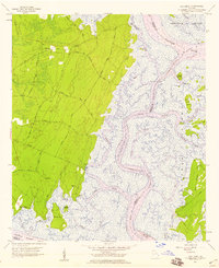
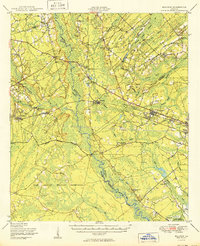 1950 Meldrim1950 Print · USGSCoastal Georgia in the late forties is defined by the rail lines and river swamps that connect inland towns like Meldrim and Blitchton. Genealogists can trace family landmarks and rural life at the Scaffletown School, Bethesda Ch, and Blitch Cem.2 unique versions available
 - 1950 Map of Limerick
 1950 Limerick1950 Print · USGSThe Georgia lowcountry at the mid-century mark shows a transition from coastal plantations to military and industrial expansion. Genealogists and historians can trace family roots through numerous sites like Dorchester Academy, Sunbury, and Scratchy Hall Cem.2 unique versions available
 - 1954 Map of St Catherines Sound, 1958 Print
 1954 St Catherines Sound1958 Print · USGSCoastal Georgia's intricate salt marshes and barrier islands are captured in the mid-1950s, showing a landscape defined by tidal rivers and the Intracostal Waterway. You can trace old landing sites and local infrastructure like the Yellow Bluff Fishing Camp, Youmans Landing Field, and several island Artesian Wells.2 unique versions available
 - 1955 Map of Savannah Beach North, 1956 Print
 1955 Savannah Beach North1956 Print · USGSThe coastal border of South Carolina and Georgia comes alive in the mid-1950s, detailing the shifting sands and maritime defenses of the Atlantic coast. Researchers can trace the military grounds of Fort Screven or locate the historic Tybee Lighthouse and the small Cem on Tybee Island.3 unique versions available
 - 1955 Map of Garden City, 1957 Print
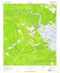
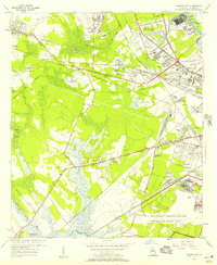 1955 Garden City1957 Print · USGSGarden City and the western outskirts of Savannah are shown here during a period of rapid aviation and rail expansion in the mid-fifties. Genealogists and historians can locate family landmarks like Silk Hope, the Lincoln Memorial Cem, and early recreational sites such as the Oglethorpe Speedway.2 unique versions available
 - 1955 Map of Fort Pulaski, 1957 Print
 1955 Fort Pulaski1957 Print · USGSCoastal South Carolina and Georgia meet at the mouth of the Savannah River in the mid-fifties, where salt marshes and tidal islands define the border. Researchers can trace historic family sites on Daufuskie Island like Mary Field Cem or locate the Lighthouse (Abandoned) near Fort Pulaski.2 unique versions available
 - 1955 Map of Port Wentworth, 1957 Print
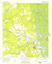 1955 Port Wentworth1957 Print · USGSCoastal Georgia at the mid-century reveals a complex landscape of river commerce and expanding rail networks north of Savannah. Genealogists and historians can trace family-named sites like Meinhard, Cherokee Hill Cem, and the old Goshen Ch as they appeared before modern development.2 unique versions available
 - 1955 Map of Limehouse, 1957 Print
 1955 Limehouse1957 Print · USGSJasper County and the Savannah River marshes are captured here in the mid-fifties, showing a landscape of coastal wetlands and rural hamlets. Genealogists can locate family landmarks like Williams Cem and Allen Cem, or trace the rail routes of the Atlantic Coast Line.2 unique versions available
 - 1955 Map of Savannah, 1957 Print
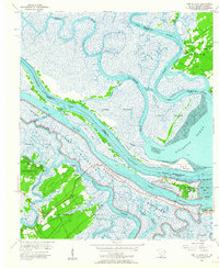
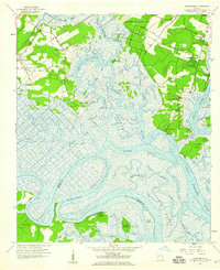
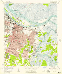 1955 Savannah1957 Print · USGSMid-century Savannah is shown in detail as it expands from its riverfront core into residential neighborhoods and across tidal marshes. Genealogists and historians can trace family locations through established areas like Ardsley Park, numerous local schools, and prominent sites like Bonaventure Cemetery or the Hunter Air Force Base.3 unique versions available
 - 1956 Map of Brunswick, 1968 Print
 1956 Brunswick1968 Print · USGSThe Georgia coast in the mid-twentieth century is a wild expanse of barrier islands and massive river deltas. You can trace the development of the maritime economy and military presence at Brunswick, or locate historic sites like Fort Frederica National Monument and Harris Neck National Wildlife Refuge.2 unique versions available
 - 1957 Map of Raccoon Key, 1959 Print
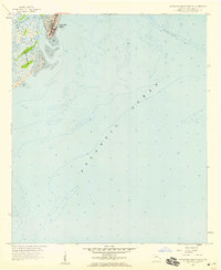
 1957 Raccoon Key1959 Print · USGSCoastal Georgia's sea island landscape is captured here in the late fifties, showing the intricate tidal networks of Ossabaw Island. Researchers can trace the early paths of Main Road and Beach Road to isolated spots like Middle Place.2 unique versions available
 - 1957 Map of Oak Level, 1959 Print
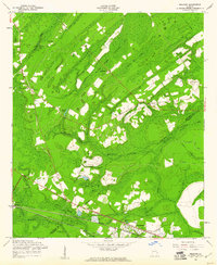
 1957 Oak Level1959 Print · USGSThe Georgia coastline near the Ogeechee and Medway rivers is shown here during the late fifties, capturing a landscape of tidal marshes and maritime forests. Genealogists and local historians can trace family-named sites like Fancy Hall, Lincoln Landing, and the Kilkenny Club.2 unique versions available
 - 1957 Map of Wassaw Sound, 1959 Print
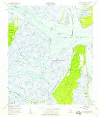
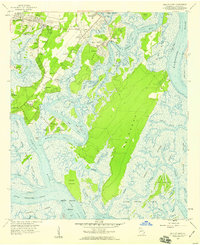
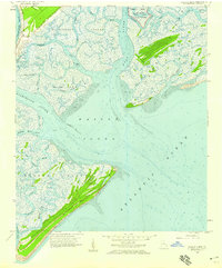 1957 Wassaw Sound1959 Print · USGSChatham County's coastal reaches were a wilderness of salt marshes and tidal rivers in the late fifties. Researchers can trace the secluded waterways of Wassaw Island or locate the historic grounds of Fort Pulaski National Monument.3 unique versions available
 - 1957 Map of Burroughs, 1959 Print
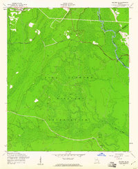
 1957 Burroughs1959 Print · USGSCoastal Chatham County in the late fifties shows a landscape of tidal marshes and rising suburbs south of Savannah. Researchers can locate Fort McAllister and old riverfront settlements like Vernonburg, Coffee Bluff, and the rail stop at Burroughs.3 unique versions available
 - 1957 Map of Savannah Beach South, 1959 Print
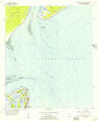
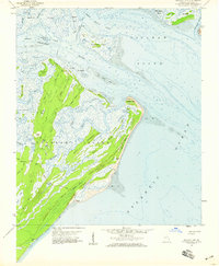
 1957 Savannah Beach South1959 Print · USGSCoastal Georgia in the late fifties is captured here as Savannah Beach meets the sea. Researchers can trace the early layout of South End and explore the maritime landscape of Tybee Creek and the surrounding Tidal Flat.2 unique versions available
 - 1957 Map of Isle of Hope, 1959 Print
 1957 Isle of Hope1959 Print · USGSCoastal Georgia's intricate island and marsh network is captured here in the late fifties, showcasing the communities south of Savannah. Researchers can locate family landmarks like Wormsloe, the Water Orphanage at Bethesda, and historic settlements such as Pin Point and Sandfly.2 unique versions available
 - 1957 Map of Savannah, 1967 Print
 1957 Savannah1967 Print · USGSThe Lowcountry and Georgia coastal plain are shown here in the late fifties, prior to modern expansion. Researchers can trace the rail-and-river economy through the Central of Georgia lines and the Ogeechee River wetlands.4 unique versions available
 - 1958 Map of Meldrim SE, 1961 Print
 1958 Meldrim SE1961 Print · USGSThe Ogeechee River corridor is shown in the late fifties as rail lines like the Central of Georgia connect local towns. Researchers can trace family sites like Hopeton Plantation, Ennis Cem, and Spring Hill Ch.4 unique versions available
 - 1958 Map of Meldrim, 1961 Print
 1958 Meldrim1961 Print · USGSThe Effingham and Chatham county line in the late fifties was a land of timber and tracks centered on the railroad junction at Meldrim. Researchers can trace old rural communities through sites like Marlow Sch, Union Ch, and the crossing of the Central of Georgia railroad.4 unique versions available
 - 1958 Map of Richmond Hill, 1961 Print
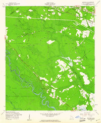
 1958 Richmond Hill1961 Print · USGSCoastal Georgia in the late fifties is defined here by the winding Ogeechee and the rise of the town of Richmond Hill. Researchers can trace family history through numerous rural cemeteries and church sites, including Strathy Hall Cem, Bryan Neck Ch, and Rabbit Hill.3 unique versions available
 - 1958 Map of Meldrim SW, 1961 Print
 1958 Meldrim SW1961 Print · USGSCoastal Georgia's transition to a military landscape is documented here during the late fifties, showing the area around the Ogeechee River. Genealogists and historians can trace the former community of Clyde (Site), finding family-named landmarks like Clyde Cem and Wise Cem.3 unique versions available
End of results
Showing maps 1-21 of 21
Top cities of Chatham County
- Savannah historical maps
- Pooler historical maps
- Wilmington Island historical maps
- Georgetown historical maps
- Garden City historical maps
- Port Wentworth historical maps
See more
Frequently asked questions
- What are the different types of historical maps available for Chatham County?
- What is the oldest map of Chatham County?
- Where can I purchase historical maps of Chatham County for my home or office?
- Where can I download high-res historical maps of Chatham County?
- Are there historical topographic maps available for Chatham County?
- Is there historical aerial imagery available for Chatham County?
- Where are historical maps of Chatham County sourced from?