1920s Maps of Chatham County, Georgia
Explore 5 historic maps of Chatham County from the 1920s. These maps offer a rare glimpse into what life looked like during the 1920s — showing old roads, neighborhoods, homes, and landmarks that have changed or disappeared over time.
Whether you're researching your family's past, planning a metal detecting trip, or studying how Chatham County's landscape evolved across the 1920s, these high-resolution maps are a powerful tool for exploring the history of this region.
- Focus on a specific era: All maps on this page are from the 1920s, giving you a focused view of this time period.
- See what’s changed: Compare century-old streets, trails, and buildings to today's modern landscape using overlays and satellite layers.
- Research with precision: Use these maps for genealogy, historical research, land use analysis, or educational projects.
- View, download, or print: Maps are fully viewable online in high resolution, and can be downloaded or printed for your own records.
Start exploring Chatham County's history through authentic maps from the 1920s. This is your window into the past.
Chatham County, GA maps
(5)- 1920 Map of Meldrim
 1920 Meldrim1920 Print · USGSCoastal Georgia during the early post-war period is defined here by the winding Ogeechee River and a busy intersection of rail lines. Genealogists and researchers can trace family roots near Clyde or locate rural landmarks like Zion Church and Miller Chapel.
 - 1920 Map of Wassaw Sound
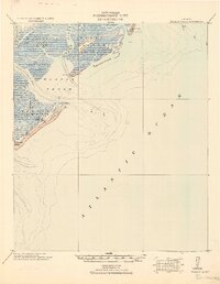 1920 Wassaw Sound1920 Print · USGSCoastal Georgia at the end of the Great War era reveals a landscape of tidal marshes and strategic barrier islands. Researchers can trace historic landmarks like the Great Wassaw Old Battery, the Cup of Hotel, and the winding Wilmington River.
 - 1920 Map of Bluffton
 1920 Bluffton1920 Print · USGSThe Georgia and South Carolina coastlines meet here in the early twentieth century, showing a world defined by tidal rivers and island outposts. Researchers can trace historic maritime landmarks like Ft. Pulaski, the Long Island Ferry, and family settlements at Spanish Wells or Hickory Bluff.
 - 1920 Map of Limerick, 1928 Print
 1920 Limerick1928 Print · USGSThe Georgia coast at the end of the Great War reveals a landscape shaped by tidal rivers and burgeoning timber railroads. Genealogists and local historians can trace family roots through the settlements of Limerick, Sunbury, and Riceboro, or locate the historic Midway Ch. and the coastal defenses of Fort Morris.
 - 1928 Map of St Catherines Island
 1928 St Catherines Island1928 Print · USGSCoastal Georgia's intricate barrier islands and marshes are captured here in the early twentieth century. Genealogists and historians can locate specific sites like Bakers House & Chimney, the Quarantine Stack, and Harris.
End of results
Showing maps 1-5 of 5
Top cities of Chatham County
- Savannah historical maps
- Pooler historical maps
- Wilmington Island historical maps
- Georgetown historical maps
- Garden City historical maps
- Port Wentworth historical maps
See more
Frequently asked questions
- What are the different types of historical maps available for Chatham County?
- What is the oldest map of Chatham County?
- Where can I purchase historical maps of Chatham County for my home or office?
- Where can I download high-res historical maps of Chatham County?
- Are there historical topographic maps available for Chatham County?
- Is there historical aerial imagery available for Chatham County?
- Where are historical maps of Chatham County sourced from?