1980s Maps of Chatham County, Georgia
Explore 7 historic maps of Chatham County from the 1980s. These maps offer a rare glimpse into what life looked like during the 1980s — showing old roads, neighborhoods, homes, and landmarks that have changed or disappeared over time.
Whether you're researching your family's past, planning a metal detecting trip, or studying how Chatham County's landscape evolved across the 1980s, these high-resolution maps are a powerful tool for exploring the history of this region.
- Focus on a specific era: All maps on this page are from the 1980s, giving you a focused view of this time period.
- See what’s changed: Compare century-old streets, trails, and buildings to today's modern landscape using overlays and satellite layers.
- Research with precision: Use these maps for genealogy, historical research, land use analysis, or educational projects.
- View, download, or print: Maps are fully viewable online in high resolution, and can be downloaded or printed for your own records.
Start exploring Chatham County's history through authentic maps from the 1980s. This is your window into the past.
Chatham County, GA maps
(7)- 1980 Map of Richmond Hill
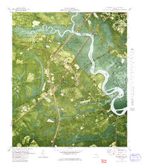 1980 Richmond Hill1980 Print · USGSThe Ogeechee River corridor is shown here as it transitioned into the 1980s, revealing a landscape of military reserves and old coastal canals. Trace family roots and local history at Byran Neck Ch, Strathy Hall Cem, and the old settlement at Burroughs.
 - 1980 Map of Garden City
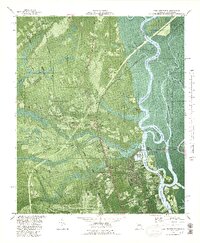
 1980 Garden City1980 Print · USGSCoastal Georgia's industrial and rail hubs are in full view during the mid-seventies, from the Savannah River terminals to the edge of Pooler. Genealogists and local historians can trace family-named sites like Waldburgh Cem, Rossignol Hill, and Silk Hope.2 unique versions available
 - 1980 Map of Limehouse
 1980 Limehouse1980 Print · USGSJasper County tidelands and the edges of the Savannah riverfront appear here in the early eighties. Genealogists can trace local roots through sites like Chisolm Cem, Jonesville Ch, and the landings at Cook Landing.2 unique versions available
 - 1980 Map of Port Wentworth
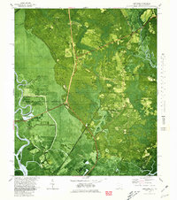
 1980 Port Wentworth1980 Print · USGSCoastal Georgia in the late seventies is captured here at the intersection of heavy industry and wilderness. Trace the rail lines of the Central of Georgia or find family landmarks like Mt Marriah Ch and Cherokee Hill Cem.2 unique versions available
 - 1980 Map of Wassaw Sound, 1983 Print
 1980 Wassaw Sound1983 Print · USGSThe Georgia coast in the early eighties reveals a fascinating mix of strategic fortifications and preserved barrier islands. Trace the marshes around Wilmington Island or locate the grounds of Fort Pulaski National Monument and the Wassaw National Wildlife Refuge.2 unique versions available
 - 1981 Map of Jesup, 1982 Print
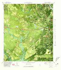
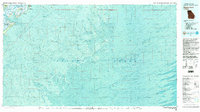
 1981 Jesup1982 Print · USGSCoastal Georgia in the early eighties shows a landscape of expansive river deltas and military reservations stretching from the interior to the Atlantic. Genealogists and local historians can trace family locations near Jesup, the old port of Sunbury, or the tidal reaches of the Altamaha River.
 - 1981 Map of Savannah, 1982 Print
 1981 Savannah1982 Print · USGSCoastal Georgia and the South Carolina borderlands are captured here in the early eighties, showing the region's complex network of riverine islands and military installations. Researchers can trace the rail lines of the Central of Georgia and explore sites like Fort Stewart Military Reservation and Garden City.
End of results
Showing maps 1-7 of 7
Top cities of Chatham County
- Savannah historical maps
- Pooler historical maps
- Wilmington Island historical maps
- Georgetown historical maps
- Garden City historical maps
- Port Wentworth historical maps
See more
Frequently asked questions
- What are the different types of historical maps available for Chatham County?
- What is the oldest map of Chatham County?
- Where can I purchase historical maps of Chatham County for my home or office?
- Where can I download high-res historical maps of Chatham County?
- Are there historical topographic maps available for Chatham County?
- Is there historical aerial imagery available for Chatham County?
- Where are historical maps of Chatham County sourced from?