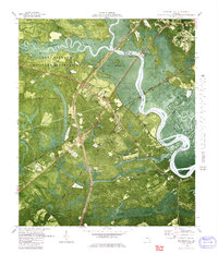
1980 Map of Richmond Hill
USGS Topo · Published 1980About this map
Ogeechee River and Canoochee River define this Georgia landscape, creating a complex network of wetlands including Lost Swamp and Poplar Swamp. The 1980 survey reveals a coastal plain heavily influenced by both military land use and historical agricultural drainage. A significant portion of the western territory is occupied by the Fort Stewart Military Reservation, while the eastern side near Richmond Hill shows an intricate system of old rice-field infrastructure, with named waterways like Peachtree Canal and Valambrosia Canal carving through the riverside flats. Genealogists can locate numerous rural landmarks such as Byran Neck Ch, Burnt Church, and Strathy Hall Cem. The presence of the Seaboard Coast Line Railroad and the U. S. Department of Agriculture Plant Introduction Garden highlights the area's mix of industrial transport and specialized land management during this era.
Find a feature on this map
55 named features on this map. Tap any name to fly to it.
Don’t see what you’re looking for? This feature index may not catch every label — zoom into the map to look around manually.
Map Details
Editions of this 1980 Richmond Hill Map
This is the sole edition of this map. No revisions or reprints were ever made.
Other maps of this area

1920 · Meldrim
USGS Topo · 1:62,500

1920 · Limerick
USGS Topo · 1:62,500

1942 · Meldrim
USGS Topo · 1:62,500

1942 · Savannah
USGS Topo · 1:62,500

1944 · Limerick
USGS Topo · 1:62,500

1944 · Ossabaw Island
USGS Topo · 1:62,500

1945 · Ossabaw Island
USGS Topo · 1:62,500

1946 · Brunswick
USGS Topo · 1:250,000

1947 · Savannah
USGS Topo · 1:250,000

1948 · Brunswick
USGS Topo · 1:250,000