1970s Maps of Canton, Georgia
Explore 2 historic maps of Canton from the 1970s. These maps offer a rare glimpse into what life looked like during the 1970s — showing old roads, neighborhoods, homes, and landmarks that have changed or disappeared over time.
Whether you're researching your family's past, planning a metal detecting trip, or studying how Canton's landscape evolved across the 1970s, these high-resolution maps are a powerful tool for exploring the history of this region.
- Focus on a specific era: All maps on this page are from the 1970s, giving you a focused view of this time period.
- See what’s changed: Compare century-old streets, trails, and buildings to today's modern landscape using overlays and satellite layers.
- Research with precision: Use these maps for genealogy, historical research, land use analysis, or educational projects.
- View, download, or print: Maps are fully viewable online in high resolution, and can be downloaded or printed for your own records.
Start exploring Canton's history through authentic maps from the 1970s. This is your window into the past.
Canton, GA maps
(2)- 1973 Map of Ball Ground West, 1975 Print
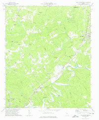 1973 Ball Ground West1975 Print · USGSCherokee County during the mid-seventies shows a landscape of river-valley towns and rural crossroads before the massive suburban expansion of later decades. Genealogists can trace family roots at Old Damascus Ch, Burris Crossroads, and along the Louisville and Nashville rail line.3 unique versions available
 - 1974 Map of Waleska, 1977 Print
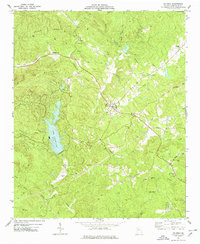 1974 Waleska1977 Print · USGSCherokee County enters a period of modern growth in the 1970s as new reservoirs and collegiate expansion reshape the mountain landscape. Genealogists and historians can trace numerous rural landmarks like Reinhardt College, Mt Zion Ch, and the Strip Mine near Polecat Mtn.2 unique versions available
End of results
Showing maps 1-2 of 2
Top cities near Canton
- Roswell historical maps
- Johns Creek historical maps
- Alpharetta historical maps
- Milton historical maps
- Kennesaw historical maps
- Woodstock historical maps
See more
Top neighborhoods of Canton
Frequently asked questions
- What are the different types of historical maps available for Canton?
- What is the oldest map of Canton?
- Where can I purchase historical maps of Canton for my home or office?
- Where can I download high-res historical maps of Canton?
- Are there historical topographic maps available for Canton?
- Is there historical aerial imagery available for Canton?
- Where are historical maps of Canton sourced from?