1990s Maps of Canton, Georgia
Explore 6 historic maps of Canton from the 1990s. These maps offer a rare glimpse into what life looked like during the 1990s — showing old roads, neighborhoods, homes, and landmarks that have changed or disappeared over time.
Whether you're researching your family's past, planning a metal detecting trip, or studying how Canton's landscape evolved across the 1990s, these high-resolution maps are a powerful tool for exploring the history of this region.
- Focus on a specific era: All maps on this page are from the 1990s, giving you a focused view of this time period.
- See what’s changed: Compare century-old streets, trails, and buildings to today's modern landscape using overlays and satellite layers.
- Research with precision: Use these maps for genealogy, historical research, land use analysis, or educational projects.
- View, download, or print: Maps are fully viewable online in high resolution, and can be downloaded or printed for your own records.
Start exploring Canton's history through authentic maps from the 1990s. This is your window into the past.
Canton, GA maps
(6)- 1992 Map of Ball Ground West, 1993 Print
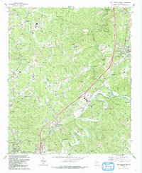 1992 Ball Ground West1993 Print · USGSCherokee County in the early 1990s reflects a landscape of river-valley settlements and growing infrastructure north of Canton. Genealogists and historians can trace several rural congregations and burial grounds, including Old Damascus Ch, McFarland Cem, and Dowda Cem.
 - 1992 Map of Canton, 1993 Print
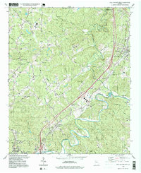
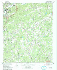 1992 Canton1993 Print · USGSCherokee County enters a period of modern growth in the early nineties, centered on the Etowah River and the expanding town of Canton. Researchers can trace family sites at St Paul Cem, find old rural hubs like Hickory Flat, or locate landmarks such as the Dean Rusk Sch and Askew County Park.
 - 1993 Map of South Canton
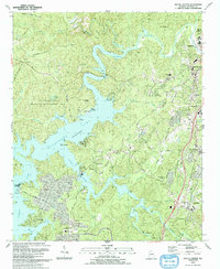 1993 South Canton1993 Print · USGSCherokee County enters a new era of growth in the early nineties as the suburban landscape expands around the shores of Allatoona Lake. Genealogists and historians can trace family ties at Lovingood Cem, old crossroads like Univeter, and the historical path of Bells Ferry.
 - 1997 Map of Waleska, 1998 Print
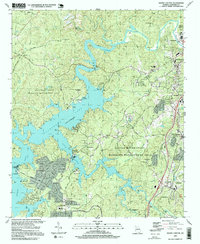
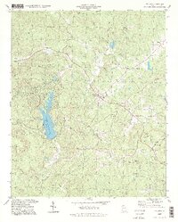 1997 Waleska1998 Print · USGSWaleska and the surrounding Cherokee County highlands are captured here in the late nineties, centered on the campus of Reinhardt College. Genealogists and historians can locate numerous rural landmarks like New Friendship Ch, Sardis Ch, and the Landing Strip near the banks of Lake Arrowhead.
 - 1997 Map of South Canton, 1999 Print
 1997 South Canton1999 Print · USGSCherokee County in the late nineties shows the balance between the growing towns of Canton and Holly Springs and the waters of Allatoona Lake. Researchers can trace local heritage through sites like Lovingood Cem, Boston Sch, and the Georgia Northern RR.
 - 1997 Map of Ball Ground West, 1999 Print
 1997 Ball Ground West1999 Print · USGSCherokee County in the late 1990s shows a landscape of river meanders and growing infrastructure along the rail corridor. Researchers can find numerous country churches and family burial sites, including Old Damascus Ch, Keithsburg, and Hickory Log Cem.
End of results
Showing maps 1-6 of 6
Top cities near Canton
- Roswell historical maps
- Johns Creek historical maps
- Alpharetta historical maps
- Milton historical maps
- Kennesaw historical maps
- Woodstock historical maps
See more
Top neighborhoods of Canton
Frequently asked questions
- What are the different types of historical maps available for Canton?
- What is the oldest map of Canton?
- Where can I purchase historical maps of Canton for my home or office?
- Where can I download high-res historical maps of Canton?
- Are there historical topographic maps available for Canton?
- Is there historical aerial imagery available for Canton?
- Where are historical maps of Canton sourced from?