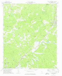
1973 Map of Ball Ground West
USGS Topo · Published 1975About this map
The Etowah River meanders through the southern half of this mid-1970s landscape, serving as a defining geographical feature between the growing community of Canton and the town of Ball Ground. The Louisville and Nashville railroad tracks parallel the river's course, cutting through Keithsburg and Gober, highlighting the transport-driven development of the corridor. Scattered throughout the wooded hills and creek valleys are numerous local landmarks essential for genealogical research, including Old Damascus Ch, Hickory Log Ch, and Welcome Valley Ch. The northern terrain is shaped by several drainages such as Soap Creek, Spence Creek, and Sharp Mountain Creek, while infrastructure developments like the Cherokee County Airport and a Filtration Plant indicate the region's mid-century modernization.
Find a feature on this map
44 named features on this map. Tap any name to fly to it.
Don’t see what you’re looking for? This feature index may not catch every label — zoom into the map to look around manually.
Map Details
Editions of this 1973 Ball Ground West Map
3 editions found
Other maps of this area

1890 · Suwanee
USGS Topo · 1:125,000

1890 · Cartersville
USGS Topo · 1:125,000

1891 · Cartersville
USGS Topo · 1:125,000

1894 · Suwanee
USGS Topo · 1:125,000

1896 · Cartersville
USGS Topo · 1:125,000

1907 · Acworth
USGS Topo · 1:62,500

1909 · Acworth
USGS Topo · 1:62,500

1926 · Tate
USGS Topo · 1:62,500

1928 · Tate
USGS Topo · 1:62,500

1947 · Waleska
USGS Topo · 1:62,500