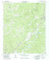
1973 Map of Ball Ground West
USGS Topo · Published 1986About this map
The Etowah River snakes through the southern portion of this Georgia landscape, providing a natural boundary as it flows past Keithsburg and the outskirts of Canton. During the mid-1970s, the region maintained a pattern of dispersed rural communities and family-named crossroads, such as Burris Crossroads and Gober. The town of Ball Ground serves as a northern anchor, positioned along the Seaboard Road rail line which dictates the local transport corridor. This area is dense with community landmarks, including Old Damascus Church near Soap Creek and Hopewell Church along Hornage Road. The survey also documents local education and infrastructure through sites like the Bunche School and the Cherokee County Airport, alongside specialized industrial footprints such as the Filtration Plant and a Quarry near the western edge of the quadrangle.
Find a feature on this map
44 named features on this map. Tap any name to fly to it.
Don’t see what you’re looking for? This feature index may not catch every label — zoom into the map to look around manually.
Map Details
Editions of this 1973 Ball Ground West Map
3 editions found
Other maps of this area

1890 · Suwanee
USGS Topo · 1:125,000

1890 · Cartersville
USGS Topo · 1:125,000

1891 · Cartersville
USGS Topo · 1:125,000

1894 · Suwanee
USGS Topo · 1:125,000

1896 · Cartersville
USGS Topo · 1:125,000

1907 · Acworth
USGS Topo · 1:62,500

1909 · Acworth
USGS Topo · 1:62,500

1926 · Tate
USGS Topo · 1:62,500

1928 · Tate
USGS Topo · 1:62,500

1947 · Waleska
USGS Topo · 1:62,500