1970s Maps of Clinch County, Georgia
Explore 11 historic maps of Clinch County from the 1970s. These maps offer a rare glimpse into what life looked like during the 1970s — showing old roads, neighborhoods, homes, and landmarks that have changed or disappeared over time.
Whether you're researching your family's past, planning a metal detecting trip, or studying how Clinch County's landscape evolved across the 1970s, these high-resolution maps are a powerful tool for exploring the history of this region.
- Focus on a specific era: All maps on this page are from the 1970s, giving you a focused view of this time period.
- See what’s changed: Compare century-old streets, trails, and buildings to today's modern landscape using overlays and satellite layers.
- Research with precision: Use these maps for genealogy, historical research, land use analysis, or educational projects.
- View, download, or print: Maps are fully viewable online in high resolution, and can be downloaded or printed for your own records.
Start exploring Clinch County's history through authentic maps from the 1970s. This is your window into the past.
Clinch County, GA maps
(11)- 1971 Map of Thelma, 1976 Print
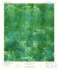
 1971 Thelma1976 Print · USGSClinch and Echols County landscapes are captured in the early 1970s, showing a region defined by extensive wetlands and rail transit. Researchers can locate specific family-named landmarks like Starling Ford, Wilkerson Lake, and the community of Thelma.
 - 1971 Map of Du Pont, 1976 Print
 1971 Du Pont1976 Print · USGSClinch County was a landscape of deep timber and rail junctions in the early seventies, captured here through detailed orthophotography. Genealogists and local historians can locate Olive Leaf Ch, Eason Cem, and the rail lines of the Seaboard and Coast Line.
 - 1971 Map of Stockton, 1976 Print
 1971 Stockton1976 Print · USGSStockton and the surrounding Georgia wetlands are captured here in the early seventies as the railroad still dictated the local geography. Researchers can find New Prospect Ch and trace the many family-named depressions like Epsey Bay and Lightsey Bay.
 - 1971 Map of Pineland, 1976 Print
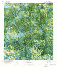
 1971 Pineland1976 Print · USGSSouthern Georgia's wetland interior is captured in the early seventies, showing the remote landscape of Echols and Clinch Counties. Researchers can locate named crossings like Brown Ford, the path of an Old Railroad Grade, and the small settlement at Pineland.
 - 1971 Map of Haylow, 1976 Print
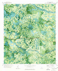
 1971 Haylow1976 Print · USGSRailroad crossroads and extensive wetlands define this south Georgia landscape in the early 1970s. Genealogists and local historians can trace rail-side settlements like Haylow and Withers or locate family landmarks near Boggy Bay and Sasser Lake.
 - 1972 Map of Sirmans, 1977 Print
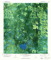
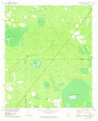
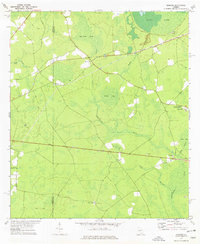 1972 Sirmans1977 Print · USGSClinch and Lanier Counties are shown in the early seventies, capturing a landscape of cypress bays and small rural outposts. Researchers can trace family roots at Arabia Cem or locate community centers like Eightmile Still and St Marks Ch.2 unique versions available
 - 1972 Map of Sandy Bottom, 1977 Print
 1972 Sandy Bottom1977 Print · USGSAtkinson and Clinch Counties in the early seventies were defined by an intricate network of wetlands and rural road crossings. Genealogists and local historians can trace family routes like Sears Road and locate rural landmarks such as Langs Ch and Sandy Bottom.2 unique versions available
 - 1972 Map of Henderson Still, 1987 Print
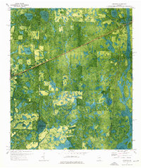
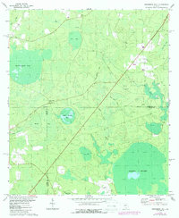 1972 Henderson Still1987 Print · USGSThe Georgia wiregrass and pine flatwoods come alive in the early 1970s at the meeting point of Atkinson, Clinch, and Lanier counties. Genealogists and local historians can locate remote landmarks like Ozias Ch, Henderson Still, and the distinctive Fifty Dollar Bay.
 - 1978 Map of Henderson Still
 1978 Henderson Still1978 Print · USGSThe rural borderlands of Atkinson and Clinch Counties come into focus during the late 1970s, showing a landscape defined by expansive swamps and bays. You can trace the roads leading to Henderson Still or locate local landmarks like Ozias Ch and Fifty Dollar Bay.
 - 1978 Map of Homerville West
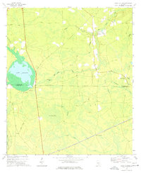
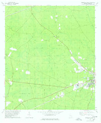 1978 Homerville West1978 Print · USGSClinch County in the late seventies is a landscape of expansive bays and timber-related history. Researchers can locate the Pine Forest Cem, trace the Seaboard Coast Line through Homerville, or explore the curiously named Useless Bay.2 unique versions available
 - 1978 Map of Waycross, 1982 Print
 1978 Waycross1982 Print · USGSSoutheast Georgia in the late seventies is a landscape of vast wetlands and busy rail junctions. Genealogists and local historians can trace the Seaboard Coast Line through rural stops like Millwood and Pearson or locate family sites near the Okefenokee Swamp.
End of results
Showing maps 1-11 of 11
Top cities of Clinch County
- Homerville historical maps
- Fargo historical maps
- Argyle historical maps
- Du Pont historical maps
- Ernest historical maps
Frequently asked questions
- What are the different types of historical maps available for Clinch County?
- What is the oldest map of Clinch County?
- Where can I purchase historical maps of Clinch County for my home or office?
- Where can I download high-res historical maps of Clinch County?
- Are there historical topographic maps available for Clinch County?
- Is there historical aerial imagery available for Clinch County?
- Where are historical maps of Clinch County sourced from?