1990s Maps of Clinch County, Georgia
Explore 9 historic maps of Clinch County from the 1990s. These maps offer a rare glimpse into what life looked like during the 1990s — showing old roads, neighborhoods, homes, and landmarks that have changed or disappeared over time.
Whether you're researching your family's past, planning a metal detecting trip, or studying how Clinch County's landscape evolved across the 1990s, these high-resolution maps are a powerful tool for exploring the history of this region.
- Focus on a specific era: All maps on this page are from the 1990s, giving you a focused view of this time period.
- See what’s changed: Compare century-old streets, trails, and buildings to today's modern landscape using overlays and satellite layers.
- Research with precision: Use these maps for genealogy, historical research, land use analysis, or educational projects.
- View, download, or print: Maps are fully viewable online in high resolution, and can be downloaded or printed for your own records.
Start exploring Clinch County's history through authentic maps from the 1990s. This is your window into the past.
Clinch County, GA maps
(9)- 1994 Map of Headlight
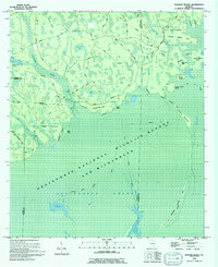
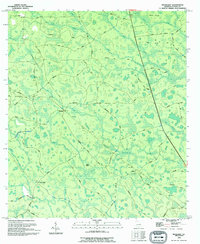 1994 Headlight1994 Print · USGSThe Clinch County wetlands are mapped here in the mid-1990s, showing a landscape of scattered settlements and named bays. Researchers can find old family landmarks and rural infrastructure like the Cem near Stavey Bay and the small community of Headlight.
 - 1994 Map of Strange Island
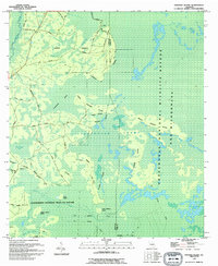 1994 Strange Island1994 Print · USGSThe interior of the Okefenokee Swamp in the early nineties reveals a complex landscape of wetlands and isolated dry ground. Genealogists and historians can trace routes to Harpers Hammock and find markers of the past like the Old Railroad Grade and Indian Mound Island.
 - 1994 Map of Sargent
 1994 Sargent1994 Print · USGSThe Florida-Georgia borderlands in the mid-nineties are defined here by the great Southern wetlands and the small outposts that edge them. Genealogists and historians can trace the remote settlements of Sargent and Traveler or locate family-named landmarks like Devils Cup and Saucer Island.
 - 1994 Map of Colon
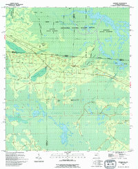
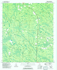
 1994 Colon1994 Print · USGSIn the heart of Clinch County during the early nineties, this area showcases the intersection of the Okefenokee Wilderness and rural settlements. Genealogists and historians can trace family markers at Williams Cem and follow the paths of the Old Railroad Grade or Old Retreat Grade Road.
 - 1994 Map of Cravens Island
 1994 Cravens Island1994 Print · USGSThe Okefenokee swamp interior in the mid-1990s reveals a complex world of island hammocks and historical timber transport. Researchers can trace the Old Railroad Grade past Hopkins and locate old landmarks like McLeods Mill and Cravens Island.
 - 1994 Map of Spooner
 1994 Spooner1994 Print · USGSThe Clinch and Ware County line was captured in the mid-nineties as it borders the great southern wetlands. Genealogists and local historians can locate Antioch Ch, trace the remote Jamestown settlement, and explore named islands like Gainey Island.
 - 1994 Map of The Pocket
 1994 The Pocket1994 Print · USGSWare County, Georgia, is shown during the 1990s as a labyrinth of swamp islands and managed wetlands. Researchers can trace family history at Mixons Cem or follow the path of an Old Railroad Grade through The Pocket.
 - 1994 Map of Midway
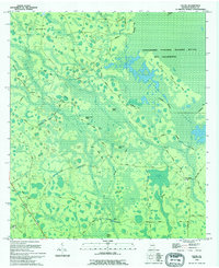
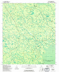
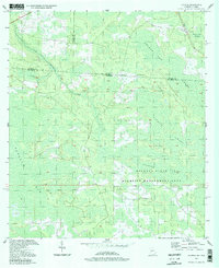
 1994 Midway1994 Print · USGSClinch County in the mid-nineties shows a landscape of expansive bays and timber tracts south of Midway. Genealogists can locate family-named landmarks like Griffis Cem, Chauncey Cem, and the rural congregation at Bethel Ch.
 - 1994 Map of Council, 1998 Print
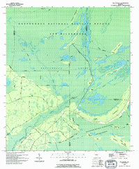
 1994 Council1998 Print · USGSThe Georgia-Florida borderlands come into focus in the 1990s, revealing a landscape defined by the Osceola State Wildlife Management Area. Researchers can trace the historic Watson Line and the winding course of Little Suwannee Creek through the Pinhook Swamp.
End of results
Showing maps 1-9 of 9
Top cities of Clinch County
- Homerville historical maps
- Fargo historical maps
- Argyle historical maps
- Du Pont historical maps
- Ernest historical maps
Frequently asked questions
- What are the different types of historical maps available for Clinch County?
- What is the oldest map of Clinch County?
- Where can I purchase historical maps of Clinch County for my home or office?
- Where can I download high-res historical maps of Clinch County?
- Are there historical topographic maps available for Clinch County?
- Is there historical aerial imagery available for Clinch County?
- Where are historical maps of Clinch County sourced from?