1990s Maps of Dawsonville, Georgia
Explore 2 historic maps of Dawsonville from the 1990s. These maps offer a rare glimpse into what life looked like during the 1990s — showing old roads, neighborhoods, homes, and landmarks that have changed or disappeared over time.
Whether you're researching your family's past, planning a metal detecting trip, or studying how Dawsonville's landscape evolved across the 1990s, these high-resolution maps are a powerful tool for exploring the history of this region.
- Focus on a specific era: All maps on this page are from the 1990s, giving you a focused view of this time period.
- See what’s changed: Compare century-old streets, trails, and buildings to today's modern landscape using overlays and satellite layers.
- Research with precision: Use these maps for genealogy, historical research, land use analysis, or educational projects.
- View, download, or print: Maps are fully viewable online in high resolution, and can be downloaded or printed for your own records.
Start exploring Dawsonville's history through authentic maps from the 1990s. This is your window into the past.
Dawsonville, GA maps
(2)- 1997 Map of Dawsonville, 1999 Print
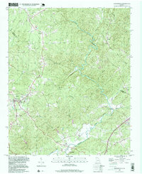 1997 Dawsonville1999 Print · USGSDawsonville and the surrounding foothills appear in detail during the late nineties, showing a landscape defined by the winding Etowah River. Local historians can trace old community centers like Auraria and Landrum, alongside genealogical markers such as New Bethel Cem and Antioch Ch.
 - 1997 Map of Juno, 1999 Print
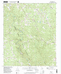 1997 Juno1999 Print · USGSDawson County in the late nineties is documented here as the local landscape transitioned between protected forest and developing rural hubs. Researchers can locate community centers like Juno, the landmark Covered Bridge, and various historic sites including McKees Chapel and West Side Sch.
End of results
Showing maps 1-2 of 2
Top cities near Dawsonville
- Gainesville historical maps
- Dahlonega historical maps
- Flowery Branch historical maps
- Cumming historical maps
- Oakwood historical maps
- Ball Ground historical maps
Frequently asked questions
- What are the different types of historical maps available for Dawsonville?
- What is the oldest map of Dawsonville?
- Where can I purchase historical maps of Dawsonville for my home or office?
- Where can I download high-res historical maps of Dawsonville?
- Are there historical topographic maps available for Dawsonville?
- Is there historical aerial imagery available for Dawsonville?
- Where are historical maps of Dawsonville sourced from?