1980s Maps of Fannin County, Georgia
Explore 14 historic maps of Fannin County from the 1980s. These maps offer a rare glimpse into what life looked like during the 1980s — showing old roads, neighborhoods, homes, and landmarks that have changed or disappeared over time.
Whether you're researching your family's past, planning a metal detecting trip, or studying how Fannin County's landscape evolved across the 1980s, these high-resolution maps are a powerful tool for exploring the history of this region.
- Focus on a specific era: All maps on this page are from the 1980s, giving you a focused view of this time period.
- See what’s changed: Compare century-old streets, trails, and buildings to today's modern landscape using overlays and satellite layers.
- Research with precision: Use these maps for genealogy, historical research, land use analysis, or educational projects.
- View, download, or print: Maps are fully viewable online in high resolution, and can be downloaded or printed for your own records.
Start exploring Fannin County's history through authentic maps from the 1980s. This is your window into the past.
Fannin County, GA maps
(14)- 1981 Map of Dalton, 1982 Print
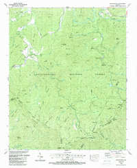
 1981 Dalton1982 Print · USGSNorth Georgia and the tristate borderlands are captured in the early eighties as the textile economy of Dalton thrived alongside the expanding Chattahoochee National Forest. Genealogists and hikers can trace the Appalachian Trail through the high country or locate family-named landmarks like Haskins Mill and Carters Mill.
 - 1988 Map of Suches
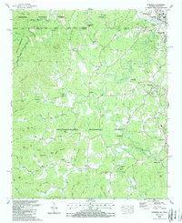
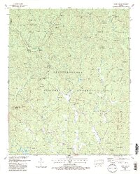
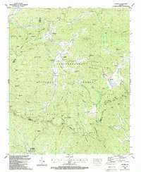 1988 Suches1988 Print · USGSUpper Georgia’s Blue Ridge highlands are shown in the late 1980s, revealing the intersection of mountain life and federal land management. Researchers can locate remote burial sites like Spriggs Cem and tracing the early footprint of Camp Merrill (U S Army).3 unique versions available
 - 1988 Map of Wilscot
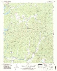 1988 Wilscot1988 Print · USGSFannin County mountain life in the late eighties is recorded here as the forest reclaimed earlier homesteads and mills. Genealogists and local historians can trace family roots at the Skeenah Creek Mill, Van Zandt Cem, and Morganton PO.3 unique versions available
 - 1988 Map of Cashes Valley
 1988 Cashes Valley1988 Print · USGSThe mountain valleys of Gilmer County are captured here in the late 1980s, just as modern developments began appearing near traditional highlands. Genealogists can trace family names at Cherry Log, Cashes Valley Church of Christ, and the Underwood Cem.2 unique versions available
 - 1988 Map of Nottely Dam
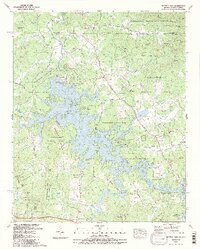 1988 Nottely Dam1988 Print · USGSThe Georgia-North Carolina borderlands come alive in the late eighties as Nottely Lake winds through the mountain forests. Researchers can locate numerous local landmarks including Ivylog Cem, Bethlehem Ch, and the agricultural grounds of Notalee Orchards.2 unique versions available
 - 1988 Map of Epworth
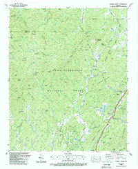
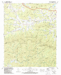
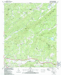
 1988 Epworth1988 Print · USGSThe Georgia-Tennessee borderlands appear here in the late eighties, centered on the mountain communities of the Ocoee River valley. Genealogists and local historians can trace rural landmarks including Patterson Mill, West Fannin Sch, and the Crestlawn Cem.
 - 1988 Map of Blue Ridge
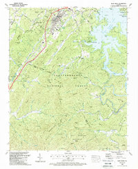 1988 Blue Ridge1988 Print · USGSBlue Ridge and the surrounding North Georgia mountains are documented here in the late eighties, just before modern development expanded. Genealogists and historians can trace family locations through Chastain Mem Park Cem, Cherry Log, and small rural churches like Union Hill Ch.2 unique versions available
 - 1988 Map of Mineral Bluff
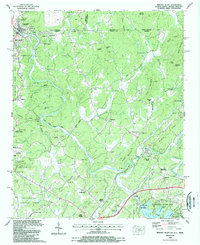 1988 Mineral Bluff1988 Print · USGSThe tri-state border country of Georgia, Tennessee, and North Carolina is captured here in the late eighties, centered on the river-and-rail corridor. Genealogists can trace family connections at Hothouse Cem, Pantertown, and the New River Ch.
 - 1988 Map of Mulky Gap
 1988 Mulky Gap1988 Print · USGSThe mountains of Union and Fannin County appear in the late eighties as a landscape of remote ridges and deep coves. Genealogists can locate family landmarks like Dillard Chapel Cem, Philadelphia Ch, and the Harkins Cem.2 unique versions available
 - 1988 Map of Dyer Gap
 1988 Dyer Gap1988 Print · USGSThe North Georgia backcountry comes to life in this late-eighties survey of the Fannin and Gilmer county line. Genealogists and hikers can trace historical sites like Gates Chapel, Nebo Cem, and the remote mountain passes at Dyer Gap and Halloway Gap.2 unique versions available
 - 1988 Map of Culberson
 1988 Culberson1988 Print · USGSThe North Carolina and Georgia state line divides this mountain landscape in the late eighties, featuring the communities of Culberson and Morganton. Genealogists can trace family names through landmarks like Mt Herman Ch, Jerusalem Cem, and New Liberty Ch.
 - 1988 Map of Noontootla
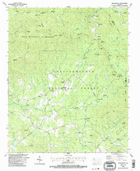
 1988 Noontootla1988 Print · USGSThe mountain gaps and forest ridges of Fannin County are captured here in the late eighties, just as the trail networks were becoming established recreation corridors. Researchers can locate remote family landmarks like Stock Hill Cem or the Fellowship Primitive Ch and trace the winding course of Noontootla Creek.3 unique versions available
 - 1988 Map of Hemp Top
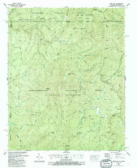 1988 Hemp Top1988 Print · USGSThe Georgia and Tennessee borderlands are captured here in the late eighties, documenting the vast mountain expanses of Fannin and Polk counties. Trace historic mountain routes like the Conasauga Wagon Road or locate the Bethlehem Ch among the high peaks of Hemp Top and Cowpen Mountain.
 - 1988 Map of Tickanetley
 1988 Tickanetley1988 Print · USGSGilmer and Fannin counties are shown here in the late eighties as a network of deep mountain valleys and river settlements. Genealogists can locate family landmarks like Tickanetley or Diamond and trace historical sites such as Macedonia Ch and Christian Ch.2 unique versions available
End of results
Showing maps 1-14 of 14
Top cities of Fannin County
Frequently asked questions
- What are the different types of historical maps available for Fannin County?
- What is the oldest map of Fannin County?
- Where can I purchase historical maps of Fannin County for my home or office?
- Where can I download high-res historical maps of Fannin County?
- Are there historical topographic maps available for Fannin County?
- Is there historical aerial imagery available for Fannin County?
- Where are historical maps of Fannin County sourced from?