1990s Maps of Fannin County, Georgia
Explore 2 historic maps of Fannin County from the 1990s. These maps offer a rare glimpse into what life looked like during the 1990s — showing old roads, neighborhoods, homes, and landmarks that have changed or disappeared over time.
Whether you're researching your family's past, planning a metal detecting trip, or studying how Fannin County's landscape evolved across the 1990s, these high-resolution maps are a powerful tool for exploring the history of this region.
- Focus on a specific era: All maps on this page are from the 1990s, giving you a focused view of this time period.
- See what’s changed: Compare century-old streets, trails, and buildings to today's modern landscape using overlays and satellite layers.
- Research with precision: Use these maps for genealogy, historical research, land use analysis, or educational projects.
- View, download, or print: Maps are fully viewable online in high resolution, and can be downloaded or printed for your own records.
Start exploring Fannin County's history through authentic maps from the 1990s. This is your window into the past.
Fannin County, GA maps
(2)- 1997 Map of Nimblewill, 2000 Print
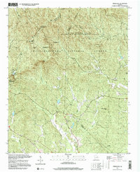 1997 Nimblewill2000 Print · USGSDawson and Lumpkin Counties come alive in this late-nineties survey of the southern Blue Ridge peaks and forest lands. Researchers can trace rural lineages through Wesley Chapel Cem, locate the Lookout Tower on Frosty Mountain, or find the small community of Emma.
 - 1999 Map of Mineral Bluff, 2001 Print
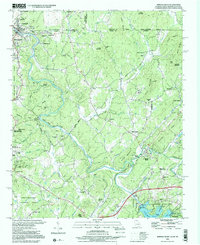 1999 Mineral Bluff2001 Print · USGSThe Georgia and Tennessee borderlands come alive in this late-century survey of the Toccoa River valley. Genealogists can trace family names through numerous rural landmarks like Douthit Cem, Mineral Bluff, and the riverside community of McCaysville.
End of results
Showing maps 1-2 of 2
Top cities of Fannin County
Frequently asked questions
- What are the different types of historical maps available for Fannin County?
- What is the oldest map of Fannin County?
- Where can I purchase historical maps of Fannin County for my home or office?
- Where can I download high-res historical maps of Fannin County?
- Are there historical topographic maps available for Fannin County?
- Is there historical aerial imagery available for Fannin County?
- Where are historical maps of Fannin County sourced from?