1960s Maps of Tallapoosa, Georgia
Explore 2 historic maps of Tallapoosa from the 1960s. These maps offer a rare glimpse into what life looked like during the 1960s — showing old roads, neighborhoods, homes, and landmarks that have changed or disappeared over time.
Whether you're researching your family's past, planning a metal detecting trip, or studying how Tallapoosa's landscape evolved across the 1960s, these high-resolution maps are a powerful tool for exploring the history of this region.
- Focus on a specific era: All maps on this page are from the 1960s, giving you a focused view of this time period.
- See what’s changed: Compare century-old streets, trails, and buildings to today's modern landscape using overlays and satellite layers.
- Research with precision: Use these maps for genealogy, historical research, land use analysis, or educational projects.
- View, download, or print: Maps are fully viewable online in high resolution, and can be downloaded or printed for your own records.
Start exploring Tallapoosa's history through authentic maps from the 1960s. This is your window into the past.
Tallapoosa, GA maps
(2)- 1965 Map of Tallapoosa South, 1968 Print
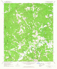
 1965 Tallapoosa South1968 Print · USGSHaralson County and the Alabama borderlands are captured here in the mid-1960s, centered on the transit hub of Tallapoosa. Genealogists and local historians can trace rural family sites like Pleasant Hill School, Antioch Cemetery, and Sanders Church.2 unique versions available
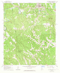
 - 1966 Map of Tallapoosa North, 1967 Print
 1966 Tallapoosa North1967 Print · USGSThe Alabama and Georgia borderlands in the 1960s were defined by the winding Tallapoosa River and a network of rural congregations. Genealogists and local historians can locate several rural landmarks including the West Haralson Sch, Steadman Missionary Cem Ch, and Pleasant Hill Ch.
End of results
Showing maps 1-2 of 2
Top cities near Tallapoosa
- Carrollton historical maps
- Bremen historical maps
- Heflin historical maps
- Bowdon historical maps
- Mount Zion historical maps
- Buchanan historical maps
See more
Top neighborhoods of Tallapoosa
Frequently asked questions
- What are the different types of historical maps available for Tallapoosa?
- What is the oldest map of Tallapoosa?
- Where can I purchase historical maps of Tallapoosa for my home or office?
- Where can I download high-res historical maps of Tallapoosa?
- Are there historical topographic maps available for Tallapoosa?
- Is there historical aerial imagery available for Tallapoosa?
- Where are historical maps of Tallapoosa sourced from?