1970s Maps of Tallapoosa, Georgia
Explore 4 historic maps of Tallapoosa from the 1970s. These maps offer a rare glimpse into what life looked like during the 1970s — showing old roads, neighborhoods, homes, and landmarks that have changed or disappeared over time.
Whether you're researching your family's past, planning a metal detecting trip, or studying how Tallapoosa's landscape evolved across the 1970s, these high-resolution maps are a powerful tool for exploring the history of this region.
- Focus on a specific era: All maps on this page are from the 1970s, giving you a focused view of this time period.
- See what’s changed: Compare century-old streets, trails, and buildings to today's modern landscape using overlays and satellite layers.
- Research with precision: Use these maps for genealogy, historical research, land use analysis, or educational projects.
- View, download, or print: Maps are fully viewable online in high resolution, and can be downloaded or printed for your own records.
Start exploring Tallapoosa's history through authentic maps from the 1970s. This is your window into the past.
Tallapoosa, GA maps
(4)- 1973 Map of Buchanan, 1975 Print
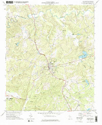 1973 Buchanan1975 Print · USGSHaralson County in the early seventies centers on the rail-side hub of Buchanan and its surrounding network of rural creek valleys. Genealogists and historians can locate numerous landmarks including Abernathys Mill, Poseyville Ch, and Estavanko Cem.2 unique versions available
 - 1973 Map of Bremen, 1975 Print
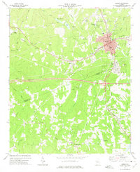 1973 Bremen1975 Print · USGSBremen and its surroundings in the early seventies show a landscape shaped by the intersection of the Southern and Central of Georgia railroads. Local historians can trace the development of small settlements like Budapest, Waco, and Mandeville, along with rural institutions like Bethlehem Ch and Jones Sch.2 unique versions available
 - 1975 Map of Tallapoosa South, 1977 Print
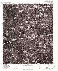 1975 Tallapoosa South1977 Print · USGSHaralson County's timberlands and rural clearings are captured from the air during the mid-seventies. Researchers can trace the path of the Tallapoosa River and locate homesteads near Lebanon or the southern outskirts of Tallapoosa.
 - 1975 Map of Tallapoosa North, 1977 Print
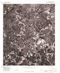 1975 Tallapoosa North1977 Print · USGSHaralson County was a patchwork of timber and small farms in the mid-1970s, as shown in this aerial orthophotoquad. Researchers can trace land use and identify early rural structures near Poplar Springs and along the winding Tallapoosa River.
End of results
Showing maps 1-4 of 4
Top cities near Tallapoosa
- Carrollton historical maps
- Bremen historical maps
- Heflin historical maps
- Bowdon historical maps
- Mount Zion historical maps
- Buchanan historical maps
See more
Top neighborhoods of Tallapoosa
Frequently asked questions
- What are the different types of historical maps available for Tallapoosa?
- What is the oldest map of Tallapoosa?
- Where can I purchase historical maps of Tallapoosa for my home or office?
- Where can I download high-res historical maps of Tallapoosa?
- Are there historical topographic maps available for Tallapoosa?
- Is there historical aerial imagery available for Tallapoosa?
- Where are historical maps of Tallapoosa sourced from?