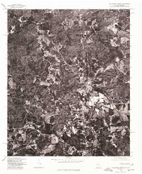
1975 Map of Tallapoosa North
USGS Topo · Published 1977About this map
The Tallapoosa River meanders through the central and eastern portions of this orthophotoquad, which covers a rural landscape in Haralson County during the mid-1970s. This imagery-based survey, produced in cooperation with the Soil Conservation Service, provides a clear view of the land-use patterns of the era, contrasting densely wooded areas with the geometric white-and-gray patches of cleared farmland and pasture. The small settlement of Poplar Springs is the primary named community, appearing as a cluster of structures along the county roads. Genealogists and local historians can trace property boundaries and road alignments as they existed just before the turn of the decade, seeing exactly where rural homesteads and agricultural tracts interfaced with the river valley.
Find a feature on this map
2 named features on this map. Tap any name to fly to it.
Don’t see what you’re looking for? This feature index may not catch every label — zoom into the map to look around manually.
Map Details
Editions of this 1975 Tallapoosa North Map
This is the sole edition of this map. No revisions or reprints were ever made.
Other maps of this area

1889 · Tallapoosa
USGS Topo · 1:125,000

1892 · Tallapoosa
USGS Topo · 1:125,000

1897 · Tallapoosa
USGS Topo · 1:125,000

1953 · Atlanta
USGS Topo · 1:250,000

1957 · Atlanta
USGS Topo · 1:250,000

1958 · Atlanta
USGS Topo · 1:250,000

1958 · Carrollton
USGS Topo · 1:62,500

1958 · Buchanan
USGS Topo · 1:62,500

1965 · Tallapoosa South
USGS Topo · 1:24,000

1966 · Tallapoosa North
USGS Topo · 1:24,000