1958 Map of Carrollton
USGS Topo · Published 1959About this map
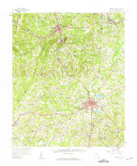
The Tallapoosa River and Little Tallapoosa River systems dictate the landscape of this mid-century survey, where rural communities are bound together by an evolving network of highways and rail lines. The city of Carrollton serves as a prominent educational and cultural anchor, home to West Georgia College and the local High Sch. To the north, the corridor between Bremen and Waco follows the Southern Railway and the Bankhead Highway, reflecting the region's historical reliance on transportation for growth.
Find a feature on this map
67 named features on this map. Tap any name to fly to it.
Don’t see what you’re looking for? This feature index may not catch every label — zoom into the map to look around manually.
Map Details
Editions of this 1958 Carrollton Map
This is the sole edition of this map. No revisions or reprints were ever made.
Other maps of this area

1889 · Tallapoosa
USGS Topo · 1:125,000

1891 · Marietta
USGS Topo · 1:125,000

1892 · Tallapoosa
USGS Topo · 1:125,000

1895 · Marietta
USGS Topo · 1:125,000

1897 · Marietta
USGS Topo · 1:125,000

1897 · Tallapoosa
USGS Topo · 1:125,000

1899 · Wedowee
USGS Topo · 1:125,000

1901 · Marietta
USGS Topo · 1:125,000

1902 · Wedowee
USGS Topo · 1:125,000

1953 · Atlanta
USGS Topo · 1:250,000