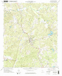
1973 Map of Buchanan
USGS Topo · Published 1975About this map
Buchanan serves as the focal point of this Haralson County landscape during the early 1970s, where the Central of Georgia railroad cuts a diagonal path through the terrain. The map documents a community defined by its rural institutions, with numerous country churches like Bethlehem Ch, Mt Vernon Ch, and Welcome Hill Ch serving the outlying areas. Water resources are central to the region's geography, from the winding path of the Tallapoosa River in the north to localized landmarks like Abernathys Mill and Edwards Lake.
Find a feature on this map
40 named features on this map. Tap any name to fly to it.
Don’t see what you’re looking for? This feature index may not catch every label — zoom into the map to look around manually.
Map Details
Editions of this 1973 Buchanan Map
2 editions found
Other maps of this area

1889 · Tallapoosa
USGS Topo · 1:125,000

1892 · Tallapoosa
USGS Topo · 1:125,000

1897 · Tallapoosa
USGS Topo · 1:125,000

1953 · Atlanta
USGS Topo · 1:250,000

1957 · Atlanta
USGS Topo · 1:250,000

1958 · Atlanta
USGS Topo · 1:250,000

1958 · Carrollton
USGS Topo · 1:62,500

1958 · Buchanan
USGS Topo · 1:62,500

1965 · Tallapoosa South
USGS Topo · 1:24,000

1966 · Tallapoosa North
USGS Topo · 1:24,000