
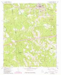
1965 Map of Tallapoosa South
USGS Topo · Published 1968About this map
The Tallapoosa River snakes through the western portion of this quadrangle, defining the border between Alabama and Georgia as it flows past the small settlement of Hooper. The town of Tallapoosa serves as the primary hub in the north, where the Southern Railway corridor facilitates transit through the hilly terrain. Local life is documented through a dense network of rural landmarks, including Pleasant Hill School and numerous country churches such as Plain View Church and Sanders Church.
Find a feature on this map
55 named features on this map. Tap any name to fly to it.
Don’t see what you’re looking for? This feature index may not catch every label — zoom into the map to look around manually.
Map Details
Editions of this 1965 Tallapoosa South Map
2 editions found
Other maps of this area

1889 · Tallapoosa
USGS Topo · 1:125,000

1892 · Tallapoosa
USGS Topo · 1:125,000

1897 · Tallapoosa
USGS Topo · 1:125,000

1953 · Atlanta
USGS Topo · 1:250,000

1957 · Atlanta
USGS Topo · 1:250,000

1958 · Atlanta
USGS Topo · 1:250,000

1958 · Carrollton
USGS Topo · 1:62,500

1958 · Buchanan
USGS Topo · 1:62,500

1966 · Tallapoosa North
USGS Topo · 1:24,000
1966 · Hightower
USGS Topo · 1:24,000