1960s Maps of Pine Mountain, Georgia
Explore 2 historic maps of Pine Mountain from the 1960s. These maps offer a rare glimpse into what life looked like during the 1960s — showing old roads, neighborhoods, homes, and landmarks that have changed or disappeared over time.
Whether you're researching your family's past, planning a metal detecting trip, or studying how Pine Mountain's landscape evolved across the 1960s, these high-resolution maps are a powerful tool for exploring the history of this region.
- Focus on a specific era: All maps on this page are from the 1960s, giving you a focused view of this time period.
- See what’s changed: Compare century-old streets, trails, and buildings to today's modern landscape using overlays and satellite layers.
- Research with precision: Use these maps for genealogy, historical research, land use analysis, or educational projects.
- View, download, or print: Maps are fully viewable online in high resolution, and can be downloaded or printed for your own records.
Start exploring Pine Mountain's history through authentic maps from the 1960s. This is your window into the past.
Pine Mountain, GA maps
(2)- 1964 Map of Pine Mountain, 1966 Print
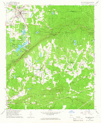 1964 Pine Mountain1966 Print · USGSHarris County and the ridges of the Pine Mountain range were transitioning into a major recreational corridor in the mid-sixties. Genealogists and local historians can trace the foundations of Pine Mountain Valley, locate the Whitehead Cemetery, and explore the early layout of Callaway Gardens.
 - 1964 Map of Durand, 1966 Print
 1964 Durand1966 Print · USGSWestern Georgia at the start of the sixties reveals a transition from rail-dependent commerce to a rural landscape of family homesteads. Genealogists can locate family burial sites at Ogletree Cem and Hardy Cem or trace the Atlantic Coast Line through Durand.
End of results
Showing maps 1-2 of 2
Top cities near Pine Mountain
- LaGrange historical maps
- Manchester historical maps
- Greenville historical maps
- Waverly Hall historical maps
- Hamilton historical maps
- Shiloh historical maps
See more
Top neighborhoods of Pine Mountain
Frequently asked questions
- What are the different types of historical maps available for Pine Mountain?
- What is the oldest map of Pine Mountain?
- Where can I purchase historical maps of Pine Mountain for my home or office?
- Where can I download high-res historical maps of Pine Mountain?
- Are there historical topographic maps available for Pine Mountain?
- Is there historical aerial imagery available for Pine Mountain?
- Where are historical maps of Pine Mountain sourced from?