Old Maps of Oakland, Georgia for Metal Detecting
Plan your next treasure hunt with 13 historic maps of Oakland. Find old homesites, ghost towns, trails, and gathering spots that may be lost to time — perfect for identifying promising metal detecting locations.
- Locate forgotten sites: Uncover places like long-lost settlements, abandoned rail lines, or gathering spots.
- Plan better hunts: Use map overlays combined with LiDAR or satellite views to narrow in on historically rich areas.
- Made for detectorists: Thousands of hobbyists use these maps to discover relics, coins, and hidden history.
Use these historic maps to boost your research and find new opportunities beneath the surface of Oakland.
Oakland, GA maps
(13)- 1950 Map of Buena Vista NE, 1953 Print
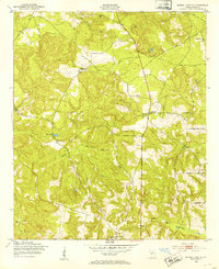 1950 Buena Vista NE1953 Print · USGSMarion County's rural landscape is captured here at mid-century, defined by small farmsteads and a rich network of community institutions. Local historians can trace the foundations of the area through Parkers Mill, Oakland Sch, and numerous churches like Bethany Ch.
 - 1950 Map of Buena Vista, 1955 Print
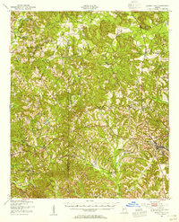 1950 Buena Vista1955 Print · USGSWest Georgia in the mid-1950s shows a landscape of rural schoolhouses and family-run mills bordering the Fort Benning Military Reservation. Researchers can locate historic rural centers like Brantley, trace the Central of Georgia rail line, and find sites like Callops Mill or Bates Chapel School and Cemetery.
 - 1955 Map of Buena Vista NE, 1959 Print
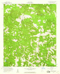 1955 Buena Vista NE1959 Print · USGSMarion County was a tapestry of small rural congregations and winding dirt roads during the mid-fifties. Genealogists can trace family connections through sites like Bethlehem Cem, Hickory Tree Ch, and Spring Hill Ch.2 unique versions available
 - 1955 Map of Buena Vista, 1961 Print
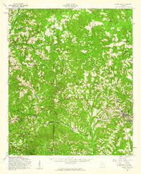 1955 Buena Vista1961 Print · USGSMid-century Marion County centers on the crossroads of Buena Vista just as the military presence at Fort Benning Military Reservation was expanding. Genealogists and historians can trace family roots through numerous rural landmarks like St Matthew Sch, Liberty Hill Ch, and Glen Alta.
 - 1955 Map of Phenix City, 1964 Print
 1955 Phenix City1964 Print · USGSPost-war Alabama and Georgia meet along the Chattahoochee River as industry and military installations expand. Trace the rail lines of the Central of Georgia through towns like Opelika, Tuskegee, and Alexander City.3 unique versions available
 - 1957 Map of Phenix City
 1957 Phenix City1957 Print · USGSThe Alabama-Georgia borderlands are captured here in the mid-fifties, centered on the bustling river crossing at Phenix City and Columbus. Researchers can trace the mid-century footprint of the Fort Benning Military Reservation or locate smaller textile and railroad towns like Langdale and Camp Hill.
 - 1958 Map of Phenix City
 1958 Phenix City1958 Print · USGSThe Alabama-Georgia borderlands thrive during the late fifties, anchored by the river-driven industry of Columbus and Phenix City. Researchers can trace the mid-century footprints of Fort Benning, Auburn, and the textile towns of Fairfax and Lanett.
 - 1981 Map of Americus, 1982 Print
 1981 Americus1982 Print · USGSWest Georgia and East Alabama appear here during the early 1980s, showcasing the transition from military reservation to agricultural heartland. Researchers can trace the Central of Georgia rail lines through towns like Plains, Ellaville, and the historic site of Andersonville.
 - 2011 Map of Buena Vista NE, 2011 Print
 2011 Buena Vista NE2011 Print · USGSCovers Oakland, including Marion County, United States, and other nearby areas
 - 2014 Map of Buena Vista NE, 2014 Print
 2014 Buena Vista NE2014 Print · USGSCovers Oakland, including Marion County, United States, and other nearby areas
 - 2017 Map of Buena Vista NE, 2017 Print
 2017 Buena Vista NE2017 Print · USGSCovers Oakland, including Marion County, United States, and other nearby areas
 - 2020 Map of Buena Vista NE, 2020 Print
 2020 Buena Vista NE2020 Print · USGSCovers Oakland, including Marion County, United States, and other nearby areas
 - 2024 Map of Buena Vista NE, 2024 Print
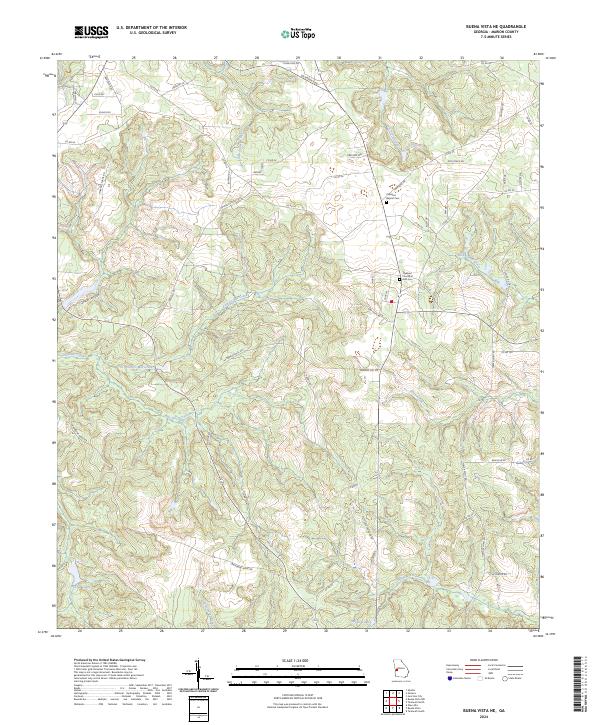 2024 Buena Vista NE2024 Print · USGSMarion County's rural landscape comes into focus in this recent survey of the region northeast of Buena Vista. Genealogists and researchers can trace local family landmarks and burial sites at the Oakland Baptist Cem, the Oakland Church of God Cem, and the settlement of Bethany.
End of results
Showing maps 1-13 of 13
Top cities near Oakland
- Columbus historical maps
- Cusseta historical maps
- Buena Vista historical maps
- Ellaville historical maps
- Talbotton historical maps
- Waverly Hall historical maps
See more
Frequently asked questions
- What are the different types of historical maps available for Oakland?
- What is the oldest map of Oakland?
- Where can I purchase historical maps of Oakland for my home or office?
- Where can I download high-res historical maps of Oakland?
- Are there historical topographic maps available for Oakland?
- Is there historical aerial imagery available for Oakland?
- Where are historical maps of Oakland sourced from?