1970s Maps of Warm Springs, Georgia
Explore 2 historic maps of Warm Springs from the 1970s. These maps offer a rare glimpse into what life looked like during the 1970s — showing old roads, neighborhoods, homes, and landmarks that have changed or disappeared over time.
Whether you're researching your family's past, planning a metal detecting trip, or studying how Warm Springs's landscape evolved across the 1970s, these high-resolution maps are a powerful tool for exploring the history of this region.
- Focus on a specific era: All maps on this page are from the 1970s, giving you a focused view of this time period.
- See what’s changed: Compare century-old streets, trails, and buildings to today's modern landscape using overlays and satellite layers.
- Research with precision: Use these maps for genealogy, historical research, land use analysis, or educational projects.
- View, download, or print: Maps are fully viewable online in high resolution, and can be downloaded or printed for your own records.
Start exploring Warm Springs's history through authentic maps from the 1970s. This is your window into the past.
Warm Springs, GA maps
(2)- 1971 Map of Shiloh, 1973 Print
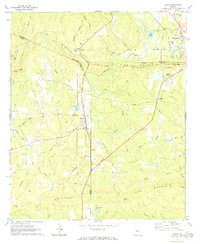 1971 Shiloh1973 Print · USGSShiloh and the surrounding ridgelines are captured here in the early seventies as the railroad and rural life defined this part of Georgia. Researchers can trace family history at Tramell Cem or locate the site of St Pauls Ch and Bulloch Crossroads.2 unique versions available
 - 1971 Map of Warm Springs, 1973 Print
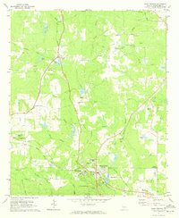 1971 Warm Springs1973 Print · USGSWestern Georgia at the start of the 1970s reveals a landscape shaped by presidential history and rural industry. Genealogists and researchers can trace family landmarks like the Judson-Bulloch Cem or visit The Little White House and Harris City.2 unique versions available
End of results
Showing maps 1-2 of 2
Top cities near Warm Springs
- Manchester historical maps
- Pine Mountain historical maps
- Woodbury historical maps
- Talbotton historical maps
- Greenville historical maps
- Waverly Hall historical maps
See more
Top neighborhoods of Warm Springs
Frequently asked questions
- What are the different types of historical maps available for Warm Springs?
- What is the oldest map of Warm Springs?
- Where can I purchase historical maps of Warm Springs for my home or office?
- Where can I download high-res historical maps of Warm Springs?
- Are there historical topographic maps available for Warm Springs?
- Is there historical aerial imagery available for Warm Springs?
- Where are historical maps of Warm Springs sourced from?