1900-1909 Maps of Columbus, Georgia
Explore 4 historic maps of Columbus from 1900-1909. These maps offer a rare glimpse into what life looked like during the 1900s — showing old roads, neighborhoods, homes, and landmarks that have changed or disappeared over time.
Whether you're researching your family's past, planning a metal detecting trip, or studying how Columbus's landscape evolved across the 1900s, these high-resolution maps are a powerful tool for exploring the history of this region.
- Focus on a specific era: All maps on this page are from the 1900s, giving you a focused view of this time period.
- See what’s changed: Compare century-old streets, trails, and buildings to today's modern landscape using overlays and satellite layers.
- Research with precision: Use these maps for genealogy, historical research, land use analysis, or educational projects.
- View, download, or print: Maps are fully viewable online in high resolution, and can be downloaded or printed for your own records.
Start exploring Columbus's history through authentic maps from the 1900s. This is your window into the past.
Columbus, GA maps
(4)- 1907 Map of Talbotton
 1907 Talbotton1907 Print · USGSWest-central Georgia at the turn of the century is a landscape of ridges and rail-lines, dominated by the thermal waters of Warm Springs. Local historians can trace the foundations of Talbotton and rural life at Turntime Crossroads, Cataula Camp Ground, and Greens Mill.3 unique versions available
 - 1907 Map of Opelika, 1963 Print
 1907 Opelika1963 Print · USGSEastern Alabama and western Georgia come alive in this early 1900s survey of the rail-and-river economy. Genealogists can trace family names at Mitchell Crossroads, find rural landmarks like the Poor Farm, and locate historic river crossings like Dixon Ferry.
 - 1908 Map of Columbus
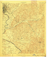 1908 Columbus1908 Print · USGSThe Chattahoochee riverfront at the dawn of the century shows the thriving river-and-rail economy of the Georgia-Alabama border. Genealogists and historians can trace early landings like BRADLEY LDG, rural congregations at Goodhope Church, and the operations at Cooks Mill.8 unique versions available
 - 1909 Map of Opelika
 1909 Opelika1909 Print · USGSEastern Alabama and western Georgia are seen here in the first decade of the twentieth century as the river-and-rail economy reached its peak. Genealogists and historians can trace old river crossings like Blanton Ferry, rural post offices such as Antioch Church Huckabee P O, and the path of the Chattahoochee Valley railroad.4 unique versions available
End of results
Showing maps 1-4 of 4
Top cities near Columbus
- Phenix City historical maps
- Cusseta historical maps
- Smiths Station historical maps
- Ladonia historical maps
- Waverly Hall historical maps
Top neighborhoods of Columbus
- Edgewood historical maps
- Patton Village historical maps
- McGraw Village historical maps
- Crystal Valley historical maps
- Fortson historical maps
- Foxfire historical maps
See more
Frequently asked questions
- What are the different types of historical maps available for Columbus?
- What is the oldest map of Columbus?
- Where can I purchase historical maps of Columbus for my home or office?
- Where can I download high-res historical maps of Columbus?
- Are there historical topographic maps available for Columbus?
- Is there historical aerial imagery available for Columbus?
- Where are historical maps of Columbus sourced from?