1930s Maps of Rabun County, Georgia
Explore 8 historic maps of Rabun County from the 1930s. These maps offer a rare glimpse into what life looked like during the 1930s — showing old roads, neighborhoods, homes, and landmarks that have changed or disappeared over time.
Whether you're researching your family's past, planning a metal detecting trip, or studying how Rabun County's landscape evolved across the 1930s, these high-resolution maps are a powerful tool for exploring the history of this region.
- Focus on a specific era: All maps on this page are from the 1930s, giving you a focused view of this time period.
- See what’s changed: Compare century-old streets, trails, and buildings to today's modern landscape using overlays and satellite layers.
- Research with precision: Use these maps for genealogy, historical research, land use analysis, or educational projects.
- View, download, or print: Maps are fully viewable online in high resolution, and can be downloaded or printed for your own records.
Start exploring Rabun County's history through authentic maps from the 1930s. This is your window into the past.
Rabun County, GA maps
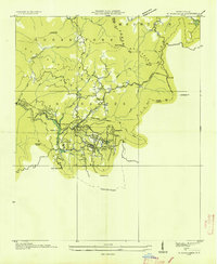
(8)- 1935 Map of Osborn
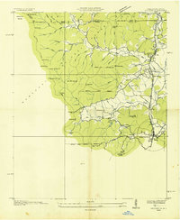
 1935 Osborn1935 Print · USGSTowns County, Georgia, is documented here in the mid-1930s before the full expansion of the Tennessee Valley Authority’s projects. Local historians can trace family locations and rural community hubs like Osborn, Macedonia Ch, and Upper Bell Sch.
 - 1935 Map of Cashiers
 1935 Cashiers1935 Print · USGSJackson County and the North Carolina-South Carolina border appear here in the mid-1930s as modern surveying techniques were first being applied. Researchers can trace early state infrastructure such as St Hy No 106 as it passes through the Nantahala National Forest.
 - 1935 Map of Dillard
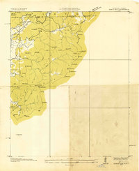
 1935 Dillard1935 Print · USGSThe Georgia and North Carolina borderlands are captured here in the mid-1930s as the rail and highway networks expanded through the mountains. Researchers can locate the Rabun Gap Nacoochee Sch, trace the Tallulah Falls RR, and find local landmarks like Wolf Fork Ch.
 - 1935 Map of Rabun Bald
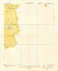
 1935 Rabun Bald1935 Print · USGSThe Georgia and North Carolina high country is captured here during the mid-thirties, dominated by the ridge lines of the Blue Ridge. Researchers can trace old mountain trails to landmarks like the Fire Tower at Rabun Bald or locate family sites near Dillard and Stillhouse Creek.
 - 1935 Map of Hightower Bald
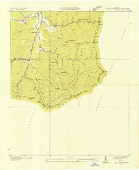
 1935 Hightower Bald1935 Print · USGSThe Georgia and North Carolina high country is captured here in the mid-1930s, showing the ridge-top border and the early Appalachian Trail. Genealogists and hikers can locate the Pleasant Hill School and the settlement of Hightower along the banks of Big Creek.
 - 1935 Map of Tray Mountain
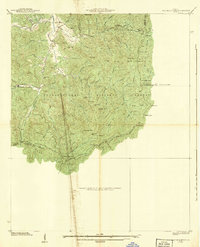
 1935 Tray Mountain1935 Print · USGSTowns County and the high Blue Ridge ridges are shown here in the mid-1930s during a period of significant New Deal infrastructure development. You can locate CCC Camp No F 15, trace the Appalachian National Trail, and find remote points like Mountain Scene.
 - 1935 Map of Highlands
 1935 Highlands1935 Print · USGSHighlands was already established as a prominent mountain destination in the mid-1930s, surrounded by the high peaks of the Blue Ridge. Genealogists and historians can trace old landmarks like Calloway Mill, the Highlands Country Club, and early hydroelectric sites like the Municipal Power Dam.
 - 1938 Map of Tray Mountain
 1938 Tray Mountain1938 Print · USGSThe Georgia mountains in the late Depression era show a landscape of federal forest land and early conservation efforts. You can trace the original route of the Appalachian Trail past Mountain Scene and the historic CCC Camp No F-15.3 unique versions available
End of results
Showing maps 1-8 of 8
Top cities of Rabun County
- Clayton historical maps
- Mountain City historical maps
- Tiger historical maps
- Dillard historical maps
- Sky Valley historical maps
Frequently asked questions
- What are the different types of historical maps available for Rabun County?
- What is the oldest map of Rabun County?
- Where can I purchase historical maps of Rabun County for my home or office?
- Where can I download high-res historical maps of Rabun County?
- Are there historical topographic maps available for Rabun County?
- Is there historical aerial imagery available for Rabun County?
- Where are historical maps of Rabun County sourced from?