1970s Maps of Seminole County, Georgia
Explore 6 historic maps of Seminole County from the 1970s. These maps offer a rare glimpse into what life looked like during the 1970s — showing old roads, neighborhoods, homes, and landmarks that have changed or disappeared over time.
Whether you're researching your family's past, planning a metal detecting trip, or studying how Seminole County's landscape evolved across the 1970s, these high-resolution maps are a powerful tool for exploring the history of this region.
- Focus on a specific era: All maps on this page are from the 1970s, giving you a focused view of this time period.
- See what’s changed: Compare century-old streets, trails, and buildings to today's modern landscape using overlays and satellite layers.
- Research with precision: Use these maps for genealogy, historical research, land use analysis, or educational projects.
- View, download, or print: Maps are fully viewable online in high resolution, and can be downloaded or printed for your own records.
Start exploring Seminole County's history through authentic maps from the 1970s. This is your window into the past.
Seminole County, GA maps
(6)- 1970 Map of Saffold, 1972 Print
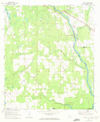 1970 Saffold1972 Print · USGSThe tri-state border of Alabama, Georgia, and Florida comes alive in the early seventies as a landscape of riverine swamps and rural hamlets. Genealogists can locate family landmarks like Pilgrims Rest Ch or trace the old rail stops at Alaga and Saffold.2 unique versions available
 - 1974 Map of Boykin, 1976 Print
 1974 Boykin1976 Print · USGSThe rural expanse of Miller and Decatur counties is captured here in the mid-seventies, showing the rail-side growth of communities like Boykin and Eldorendo. Genealogists can locate family landmarks including Lane Cem, Evergreen Ch, and Pilgrims Rest Ch.
 - 1974 Map of Donalsonville East, 1976 Print
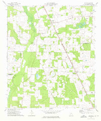
 1974 Donalsonville East1976 Print · USGSSeminole County was a landscape of quiet agricultural hamlets and rail-side settlements in the mid-seventies. Genealogists can trace family landmarks like Friendship Cem and Miller Cems, or locate rural congregations at Corinth Ch and New Home Ch.
 - 1974 Map of Donalsonville West, 1976 Print
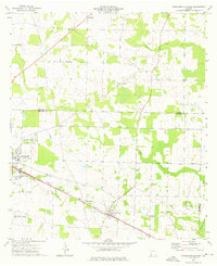
 1974 Donalsonville West1976 Print · USGSDonalsonville and Jakin appear at a mid-seventies crossroads of rail and river commerce along the Seminole and Early county lines. Researchers can trace rural community life through numerous landmarks like Newberry Ch, the Seaboard Coast Line tracks, and Little Hope.
 - 1978 Map of Bainbridge, 1980 Print
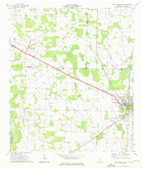
 1978 Bainbridge1980 Print · USGSIn the late seventies, this Georgia-Florida borderland was defined by the confluence of the Flint and Chattahoochee rivers. Trace the region's infrastructure via the Seaboard Coast Line Railroad and find sites like Bainbridge State Hospital.
 - 1979 Map of Marianna, 1980 Print
 1979 Marianna1980 Print · USGSFlorida's northern panhandle and the neighboring Alabama-Georgia borderlands are captured here in the late seventies. Genealogists and local historians can trace family roots through settlements like Graceville and Cottondale or follow the historic Louisville and Nashville rail lines.2 unique versions available
End of results
Showing maps 1-6 of 6
Top cities of Seminole County
Frequently asked questions
- What are the different types of historical maps available for Seminole County?
- What is the oldest map of Seminole County?
- Where can I purchase historical maps of Seminole County for my home or office?
- Where can I download high-res historical maps of Seminole County?
- Are there historical topographic maps available for Seminole County?
- Is there historical aerial imagery available for Seminole County?
- Where are historical maps of Seminole County sourced from?