1990s Maps of Seminole County, Georgia
Explore 5 historic maps of Seminole County from the 1990s. These maps offer a rare glimpse into what life looked like during the 1990s — showing old roads, neighborhoods, homes, and landmarks that have changed or disappeared over time.
Whether you're researching your family's past, planning a metal detecting trip, or studying how Seminole County's landscape evolved across the 1990s, these high-resolution maps are a powerful tool for exploring the history of this region.
- Focus on a specific era: All maps on this page are from the 1990s, giving you a focused view of this time period.
- See what’s changed: Compare century-old streets, trails, and buildings to today's modern landscape using overlays and satellite layers.
- Research with precision: Use these maps for genealogy, historical research, land use analysis, or educational projects.
- View, download, or print: Maps are fully viewable online in high resolution, and can be downloaded or printed for your own records.
Start exploring Seminole County's history through authentic maps from the 1990s. This is your window into the past.
Seminole County, GA maps
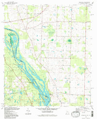
(5)- 1994 Map of Bascom, 1998 Print
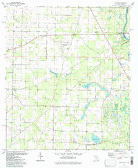 1994 Bascom1998 Print · USGSThe Chattahoochee River borderlands come into focus in the 1990s, revealing a landscape of rural junctions and abundant wetlands. Genealogists and historians can locate family landmarks like Bazzell Cem and Shiloh Ch alongside the decommissioned Auxiliary Field No 3.
 - 1994 Map of Sneads, 1998 Print
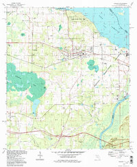 1994 Sneads1998 Print · USGSJackson County, Florida, is captured here in the 1990s as a vital crossroads of river commerce and state conservation. Researchers can trace historic family burial sites and local congregations including Sardis Cem, St Peter Cem, and Sinai Ch.
 - 1994 Map of Fairchild, 1998 Print
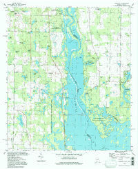 1994 Fairchild1998 Print · USGSThe Georgia-Florida borderlands come to life in the 1990s as the river landscape shifts between recreation and old riverfront settlements. Genealogists and historians can trace family roots at Fairchild Cem or explore the river's edge at Butlers Ferry Landing and Parramore Landing.
 - 1994 Map of Chattahoochee, 1998 Print
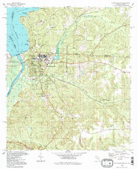 1994 Chattahoochee1998 Print · USGSChattahoochee and the Florida-Georgia border are captured here in the mid-1990s at the critical junction of the Flint and Apalachicola Rivers. Researchers can trace institutional history at the Florida State Hospital or locate family sites like White Cem and Hardin Heights.
 - 1994 Map of Steam Mill, 1998 Print
 1994 Steam Mill1998 Print · USGSThe Georgia and Florida borderlands are captured here in the mid-nineties as the river economy gave way to conservation and lake life. Genealogists can trace family footprints at Lela Courthouse and numerous burial sites like Brunson Cem or Williams Cem.
End of results
Showing maps 1-5 of 5
Top cities of Seminole County
Frequently asked questions
- What are the different types of historical maps available for Seminole County?
- What is the oldest map of Seminole County?
- Where can I purchase historical maps of Seminole County for my home or office?
- Where can I download high-res historical maps of Seminole County?
- Are there historical topographic maps available for Seminole County?
- Is there historical aerial imagery available for Seminole County?
- Where are historical maps of Seminole County sourced from?