1970s Maps of Americus, Georgia
Explore 2 historic maps of Americus from the 1970s. These maps offer a rare glimpse into what life looked like during the 1970s — showing old roads, neighborhoods, homes, and landmarks that have changed or disappeared over time.
Whether you're researching your family's past, planning a metal detecting trip, or studying how Americus's landscape evolved across the 1970s, these high-resolution maps are a powerful tool for exploring the history of this region.
- Focus on a specific era: All maps on this page are from the 1970s, giving you a focused view of this time period.
- See what’s changed: Compare century-old streets, trails, and buildings to today's modern landscape using overlays and satellite layers.
- Research with precision: Use these maps for genealogy, historical research, land use analysis, or educational projects.
- View, download, or print: Maps are fully viewable online in high resolution, and can be downloaded or printed for your own records.
Start exploring Americus's history through authentic maps from the 1970s. This is your window into the past.
Americus, GA maps
(2)- 1973 Map of Americus, 1975 Print
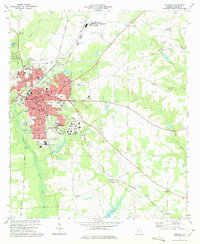 1973 Americus1975 Print · USGSAmericus was a thriving South Georgia center in the mid-1970s, defined by its historic college campus and a busy junction of multiple rail lines. Genealogists and historians can trace family roots through numerous sites like Mt Moriah Ch, Gatewood Cem, and Souther Field.2 unique versions available
 - 1973 Map of Lake Collins, 1975 Print
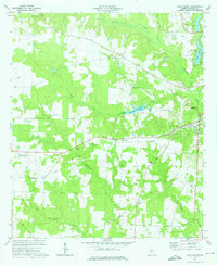 1973 Lake Collins1975 Print · USGSSumter County was a landscape of rail-linked hamlets and creekside farms in the early seventies. Genealogists and historians can trace the foundations of local life through the Antioch Ch Cem, Ebenezer Ch, and the crossroads at New Point.2 unique versions available
End of results
Showing maps 1-2 of 2
Top cities near Americus
- Montezuma historical maps
- Ellaville historical maps
- Oglethorpe historical maps
- Plains historical maps
- Smithville historical maps
- Leslie historical maps
See more
Top neighborhoods of Americus
Frequently asked questions
- What are the different types of historical maps available for Americus?
- What is the oldest map of Americus?
- Where can I purchase historical maps of Americus for my home or office?
- Where can I download high-res historical maps of Americus?
- Are there historical topographic maps available for Americus?
- Is there historical aerial imagery available for Americus?
- Where are historical maps of Americus sourced from?