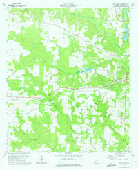
1973 Map of Lake Collins
USGS Topo · Published 1975About this map
The Seaboard Coast Line railroad cuts across this western Sumter County landscape, linking the rural communities of New Point and Thalean. The terrain is defined by a dense network of waterways, including Muckalee Creek, Wolf Creek, and Muckaloochee Creek, which feed into local landmarks like the McMath Millpond. This early 1970s survey documents a well-established network of country churches that served the agricultural population, such as Union Whitely Ch, Rehoboth Ch, and Mt Salem Ch. Significant institutional presence is marked by the Experimental Station (Univ of Ga) and the Radio Tower (WISK) near the Americus city limits. This map reveals the transition between the rolling farmland and the riparian corridors of central Georgia, capturing a snapshot of the region's rural infrastructure before significant modern expansion.
Find a feature on this map
29 named features on this map. Tap any name to fly to it.
Don’t see what you’re looking for? This feature index may not catch every label — zoom into the map to look around manually.
Map Details
Editions of this 1973 Lake Collins Map
2 editions found
Other maps of this area

1953 · Dothan
USGS Topo · 1:250,000

1954 · Dothan
USGS Topo · 1:250,000

1955 · Dothan
USGS Topo · 1:250,000

1955 · Phenix City
USGS Topo · 1:250,000

1956 · Leslie
USGS Topo · 1:62,500

1957 · Phenix City
USGS Topo · 1:250,000

1958 · Phenix City
USGS Topo · 1:250,000

1972 · Ellaville South
USGS Topo · 1:24,000
1972 · Andersonville
USGS Topo · 1:24,000
1973 · Americus
USGS Topo · 1:24,000