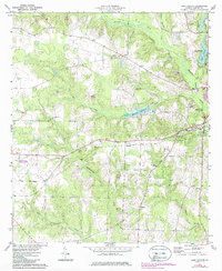
1973 Map of Lake Collins
USGS Topo · Published 1986About this map
Muckalee Creek and its complex network of tributaries, including Wolf Creek and Muckatoochee Creek, carve through the agricultural landscape of Sumter County. This 1970s environment shows a rural economy defined by water management and institutional land use, anchored by the Southwest Georgia Experiment Station and several mill-related water bodies like McMath Millpond and Parkers Mill Creek. The Seaboard railroad serves as the primary industrial artery, cutting east-west past the rural settlements of New Point and Thalean.
Find a feature on this map
30 named features on this map. Tap any name to fly to it.
Don’t see what you’re looking for? This feature index may not catch every label — zoom into the map to look around manually.
Map Details
Editions of this 1973 Lake Collins Map
2 editions found
Other maps of this area

1953 · Dothan
USGS Topo · 1:250,000

1954 · Dothan
USGS Topo · 1:250,000

1955 · Dothan
USGS Topo · 1:250,000

1955 · Phenix City
USGS Topo · 1:250,000

1956 · Leslie
USGS Topo · 1:62,500

1957 · Phenix City
USGS Topo · 1:250,000

1958 · Phenix City
USGS Topo · 1:250,000

1972 · Ellaville South
USGS Topo · 1:24,000
1972 · Andersonville
USGS Topo · 1:24,000
1973 · Americus
USGS Topo · 1:24,000