1970s Maps of Wilkes County, Georgia
Explore 11 historic maps of Wilkes County from the 1970s. These maps offer a rare glimpse into what life looked like during the 1970s — showing old roads, neighborhoods, homes, and landmarks that have changed or disappeared over time.
Whether you're researching your family's past, planning a metal detecting trip, or studying how Wilkes County's landscape evolved across the 1970s, these high-resolution maps are a powerful tool for exploring the history of this region.
- Focus on a specific era: All maps on this page are from the 1970s, giving you a focused view of this time period.
- See what’s changed: Compare century-old streets, trails, and buildings to today's modern landscape using overlays and satellite layers.
- Research with precision: Use these maps for genealogy, historical research, land use analysis, or educational projects.
- View, download, or print: Maps are fully viewable online in high resolution, and can be downloaded or printed for your own records.
Start exploring Wilkes County's history through authentic maps from the 1970s. This is your window into the past.
Wilkes County, GA maps
(11)- 1970 Map of Jacksons Crossroads, 1973 Print
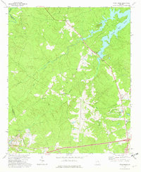
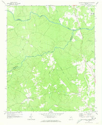 1970 Jacksons Crossroads1973 Print · USGSWilkes County and its neighbors come alive in the early 1970s as the Broad River winds through a landscape of historic small settlements. Researchers can trace the Old Railroad Grade and locate ancestral sites like Mallorysville, Clark Station Ch, and St Johns Cem.
 - 1971 Map of Vesta, 1973 Print
 1971 Vesta1973 Print · USGSOglethorpe County in the early seventies was a landscape of granite extraction and rural congregations. Genealogists and historians can trace family locations near Saxon, Veribest, and numerous landmarks like Watkins Grove Ch or Fort Bethel Ch.2 unique versions available
 - 1971 Map of Celeste, 1973 Print
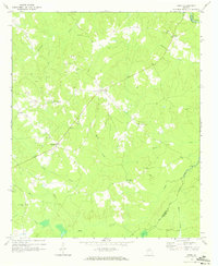
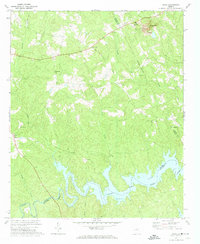
 1971 Celeste1973 Print · USGSWilkes County at the start of the 1970s reveals a Piedmont landscape where historic rural settlements like Linesville and Celeste remained centered around their country churches. You can trace the Old Railroad Grade and locate family landmarks such as Jacksons Store and Hilliard Station Ch.
 - 1971 Map of Rayle, 1973 Print
 1971 Rayle1973 Print · USGSThe borderlands of Oglethorpe and Wilkes counties are captured here in the early seventies, showing a rural landscape tied to the land and local congregation. Genealogists can locate family landmarks like Chafin Cem, Stevens Grove Ch, and the settlement at Rayle.
 - 1971 Map of Woodlawn, 1974 Print
 1971 Woodlawn1974 Print · USGSLincoln County and its neighbors are seen here in the early seventies, as the sprawling waters of Clark Hill Lake redefined the local landscape. Genealogists can trace rural roots through landmarks like Loco Holiness Ch, Antioch Ch, and the settlement at Leathersville.
 - 1972 Map of Wrightsboro, 1974 Print
 1972 Wrightsboro1974 Print · USGSMcDuffie County in the early seventies shows the rural community of Wrightsboro as it balanced traditional church life with new development. Researchers can find family landmarks like Brinkley Chapel and Pine Grove Ch, or trace the shoreline of Clark Hill Lake.3 unique versions available
 - 1972 Map of Aonia, 1974 Print
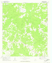
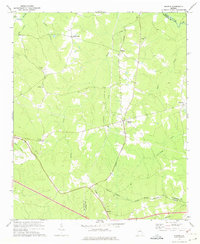
 1972 Aonia1974 Print · USGSWilkes County life in the early seventies centered on rural crossroads and the rising waters of the Little River. Genealogists can locate family landmarks like Hearns Chapel Cem, the Ship Mine, and the settlement of Aonia.2 unique versions available
 - 1972 Map of Sharon, 1974 Print
 1972 Sharon1974 Print · USGSTaliaferro County in the early seventies is characterized here by its quiet rural crossroads and winding creek networks. Genealogists can trace family roots through landmarks like Mt Olive Ch, Raytown, and the small community of Sharon.2 unique versions available
 - 1972 Map of Cadley, 1974 Print
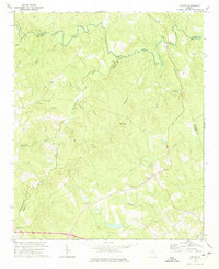 1972 Cadley1974 Print · USGSThe Georgia Piedmont at the start of the seventies is captured here as a landscape of rural congregations and family-named creeks. Genealogists can trace the location of South Liberty Church, Ebenezer Cem, and the Fountain Campground near Cadley.
 - 1972 Map of Washington East, 1975 Print
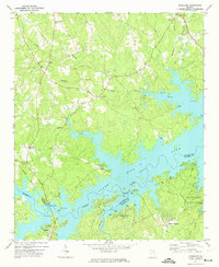
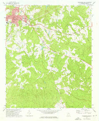 1972 Washington East1975 Print · USGSWilkes County life in the early 1970s centered on the town of Washington, where civic landmarks met a sprawling network of rural country churches. Researchers can trace family roots through several cemeteries and local landmarks like Clifford Grove Ch or Lundberg.2 unique versions available
 - 1972 Map of Washington West, 1975 Print
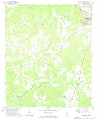 1972 Washington West1975 Print · USGSWilkes County enters the 1970s with its rural character intact, anchored by the western outskirts of Washington and the waters of the Little River. Researchers can trace local heritage through landmarks like Bethel Church, Simpson Cemetery, and the Georgia Railroad line.2 unique versions available
End of results
Showing maps 1-11 of 11
Top cities of Wilkes County
Frequently asked questions
- What are the different types of historical maps available for Wilkes County?
- What is the oldest map of Wilkes County?
- Where can I purchase historical maps of Wilkes County for my home or office?
- Where can I download high-res historical maps of Wilkes County?
- Are there historical topographic maps available for Wilkes County?
- Is there historical aerial imagery available for Wilkes County?
- Where are historical maps of Wilkes County sourced from?