1980s Maps of Hawaiian Ocean View, Hawaii
Explore 5 historic maps of Hawaiian Ocean View from the 1980s. These maps offer a rare glimpse into what life looked like during the 1980s — showing old roads, neighborhoods, homes, and landmarks that have changed or disappeared over time.
Whether you're researching your family's past, planning a metal detecting trip, or studying how Hawaiian Ocean View's landscape evolved across the 1980s, these high-resolution maps are a powerful tool for exploring the history of this region.
- Focus on a specific era: All maps on this page are from the 1980s, giving you a focused view of this time period.
- See what’s changed: Compare century-old streets, trails, and buildings to today's modern landscape using overlays and satellite layers.
- Research with precision: Use these maps for genealogy, historical research, land use analysis, or educational projects.
- View, download, or print: Maps are fully viewable online in high resolution, and can be downloaded or printed for your own records.
Start exploring Hawaiian Ocean View's history through authentic maps from the 1980s. This is your window into the past.
Hawaiian Ocean View, HI maps
(5)- 1980 Map of Hawaii County Sheet 3, 1984 Print
 1980 Hawaii County Sheet 31984 Print · USGSThe Big Island's South Kona and Kau districts are captured here in the early 1980s, from the historic coffee lands to the southern tip. Researchers can trace the layout of coastal villages and sugar-era settlements like Milolii, Pahala, and the City of Refuge Nat Historical Pk.
 - 1981 Map of Kahuku Ranch
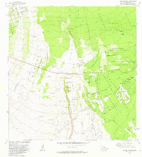 1981 Kahuku Ranch1981 Print · USGSKa'u's volcanic landscape is captured here in the early eighties, showcasing the intersection of active geology and ranching life. Researchers can find old agricultural sites at Kahuku Ranch and trace sacred locations like Heiau o Malino.
 - 1981 Map of Papa
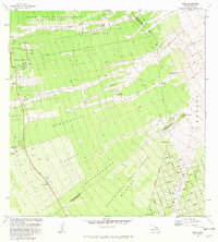 1981 Papa1981 Print · USGSSouth Kona in the early eighties reveals a landscape defined by volcanic history and upland forestry. Genealogists can trace family lands at Papa Homesteads or locate cultural markers like the Hoopuloa Church Monument and old industrial sites like Ohia Mill.
 - 1981 Map of Puu O Keokeo
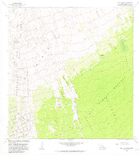 1981 Puu O Keokeo1981 Print · USGSThe slopes of Mauna Loa's rift zone are mapped in detail during the early eighties, showing a landscape defined by volcanic history. Trace the paths of the Kahuku Lava Flow of 1926 and locate sites like Wright Camp (Site) or the Halepohaha (Ruins).
 - 1981 Map of Pohue Bay
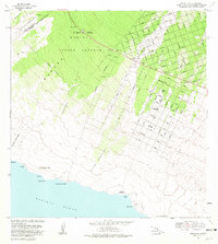 1981 Pohue Bay1981 Print · USGSThe South Kona and Kau Districts transition from forest reserves to coastal lava flows in the early eighties. Genealogists and historians can trace residential growth along Aloha Blvd or locate ancient Petroglyphs near the shores of Pohue Bay.2 unique versions available
End of results
Showing maps 1-5 of 5
Top cities near Hawaiian Ocean View
Top neighborhoods of Hawaiian Ocean View
- Country Garden Estates historical maps
- Hawaiian Ocean View historical maps
- Hawaiian Ocean View Estates historical maps
- Hawaiian Ranchos historical maps
- Kona South Estates historical maps
Frequently asked questions
- What are the different types of historical maps available for Hawaiian Ocean View?
- What is the oldest map of Hawaiian Ocean View?
- Where can I purchase historical maps of Hawaiian Ocean View for my home or office?
- Where can I download high-res historical maps of Hawaiian Ocean View?
- Are there historical topographic maps available for Hawaiian Ocean View?
- Is there historical aerial imagery available for Hawaiian Ocean View?
- Where are historical maps of Hawaiian Ocean View sourced from?