1960s Maps of Hawaiian Ocean View, Hawaii
Explore 6 historic maps of Hawaiian Ocean View from the 1960s. These maps offer a rare glimpse into what life looked like during the 1960s — showing old roads, neighborhoods, homes, and landmarks that have changed or disappeared over time.
Whether you're researching your family's past, planning a metal detecting trip, or studying how Hawaiian Ocean View's landscape evolved across the 1960s, these high-resolution maps are a powerful tool for exploring the history of this region.
- Focus on a specific era: All maps on this page are from the 1960s, giving you a focused view of this time period.
- See what’s changed: Compare century-old streets, trails, and buildings to today's modern landscape using overlays and satellite layers.
- Research with precision: Use these maps for genealogy, historical research, land use analysis, or educational projects.
- View, download, or print: Maps are fully viewable online in high resolution, and can be downloaded or printed for your own records.
Start exploring Hawaiian Ocean View's history through authentic maps from the 1960s. This is your window into the past.
Hawaiian Ocean View, HI maps
(6)- 1961 Map of Hawaii South
 1961 Hawaii South1961 Print · USGSThe southern region of the Big Island appears here in the early sixties, illustrating a landscape of volcanic craters and remote agricultural outposts. Genealogists and historians can trace the locations of Wood Valley Camp, the Koa Mill, and the ruins at Kahio.
 - 1962 Map of Hawaii South
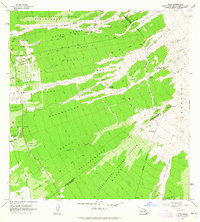
 1962 Hawaii South1962 Print · USGSThe southern half of Hawaii Island in the early sixties showcases a landscape defined by volcanic rifts and coastal settlements. Researchers can trace the Hawaii Consolidated rail line, find the Kuee (Ruined) site, and locate remote camps like Hooper Camp.2 unique versions available
 - 1962 Map of Kahuku Ranch, 1964 Print
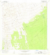
 1962 Kahuku Ranch1964 Print · USGSThe volcanic Kau District is captured here in the early sixties, showing the intersection of massive historical lava flows and ranching life. Trace the boundaries of the Kiolakaa-Keaa Homesteads or locate the Heiau o Malino and Naohulehua Cave.2 unique versions available
 - 1962 Map of Pohue Bay, 1964 Print
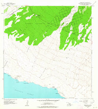 1962 Pohue Bay1964 Print · USGSCoastal Hawaii in the early sixties showcases a landscape shaped by volcanic activity and nascent development. Researchers can trace historic paths like the Petroglyphs Trail or locate remote landmarks including the Manuka Mauka House and Pohue Bay.3 unique versions available
 - 1962 Map of Papa, 1964 Print
 1962 Papa1964 Print · USGSThe South Kona coast in the early sixties reveals a landscape shaped by recent volcanic eruptions and timber milling. Researchers can trace the paths of several major eruptions through the South Kona Forest Reserve or locate local landmarks like the Koa Mill and Hoopuloa Church.2 unique versions available
 - 1967 Map of Puu O Keokeo, 1968 Print
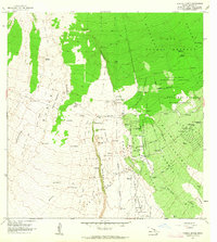
 1967 Puu O Keokeo1968 Print · USGSThe volcanic slopes of southern Hawaii are captured here in the late sixties as new residential grids begin to creep across historical lava fields. Researchers can trace the intersection of modern roads like Ocean View Drive with older landmarks such as Halepohaha (Ruins) and Wright Camp.
End of results
Showing maps 1-6 of 6
Top cities near Hawaiian Ocean View
Top neighborhoods of Hawaiian Ocean View
- Country Garden Estates historical maps
- Hawaiian Ocean View historical maps
- Hawaiian Ocean View Estates historical maps
- Hawaiian Ranchos historical maps
- Kona South Estates historical maps
Frequently asked questions
- What are the different types of historical maps available for Hawaiian Ocean View?
- What is the oldest map of Hawaiian Ocean View?
- Where can I purchase historical maps of Hawaiian Ocean View for my home or office?
- Where can I download high-res historical maps of Hawaiian Ocean View?
- Are there historical topographic maps available for Hawaiian Ocean View?
- Is there historical aerial imagery available for Hawaiian Ocean View?
- Where are historical maps of Hawaiian Ocean View sourced from?