1990s Maps of Hawaiian Ocean View, Hawaii
Explore 4 historic maps of Hawaiian Ocean View from the 1990s. These maps offer a rare glimpse into what life looked like during the 1990s — showing old roads, neighborhoods, homes, and landmarks that have changed or disappeared over time.
Whether you're researching your family's past, planning a metal detecting trip, or studying how Hawaiian Ocean View's landscape evolved across the 1990s, these high-resolution maps are a powerful tool for exploring the history of this region.
- Focus on a specific era: All maps on this page are from the 1990s, giving you a focused view of this time period.
- See what’s changed: Compare century-old streets, trails, and buildings to today's modern landscape using overlays and satellite layers.
- Research with precision: Use these maps for genealogy, historical research, land use analysis, or educational projects.
- View, download, or print: Maps are fully viewable online in high resolution, and can be downloaded or printed for your own records.
Start exploring Hawaiian Ocean View's history through authentic maps from the 1990s. This is your window into the past.
Hawaiian Ocean View, HI maps
(4)- 1995 Map of Papa, 2000 Print
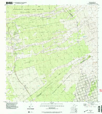 1995 Papa2000 Print · USGSSouth Kona at the end of the millennium reveals a landscape shaped by volcanic history and modern development. Trace the intersection of the Alika Lava Flow of 1919 with historic sites like the Koa Mill and the Ho'opuloa Church & Monument.
 - 1995 Map of Pohue Bay, 2000 Print
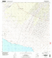 1995 Pohue Bay2000 Print · USGSThe southern coast of the Big Island in the mid-1990s reveals a unique intersection of massive volcanic flows and modern residential development. Researchers can trace the geometric grid of Ocean View alongside the Manuka Mauka House (Site) and Pohue Bay.
 - 1995 Map of Puu O Keokeo, 2000 Print
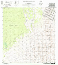 1995 Puu O Keokeo2000 Print · USGSThe Southwest Rift Zone of Hawaii appears here in the mid-nineties as a landscape defined by historic eruptions and modern growth. Researchers can trace the massive Lava Flow of 1950 and locate the former Wright Camp near the Kahuku Forest Reserve.
 - 1995 Map of Kahuku Ranch, 2000 Print
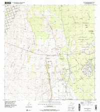 1995 Kahuku Ranch2000 Print · USGSThe ranching and volcanic landscapes of Hawaii's Ka'u District are captured here during the mid-nineties. Researchers can trace land allotments in the Kiolaka'a - Kea'a Homesteads and locate landmarks like the Kahuku Ranch or the local Cemetery.
End of results
Showing maps 1-4 of 4
Top cities near Hawaiian Ocean View
Top neighborhoods of Hawaiian Ocean View
- Country Garden Estates historical maps
- Hawaiian Ocean View historical maps
- Hawaiian Ocean View Estates historical maps
- Hawaiian Ranchos historical maps
- Kona South Estates historical maps
Frequently asked questions
- What are the different types of historical maps available for Hawaiian Ocean View?
- What is the oldest map of Hawaiian Ocean View?
- Where can I purchase historical maps of Hawaiian Ocean View for my home or office?
- Where can I download high-res historical maps of Hawaiian Ocean View?
- Are there historical topographic maps available for Hawaiian Ocean View?
- Is there historical aerial imagery available for Hawaiian Ocean View?
- Where are historical maps of Hawaiian Ocean View sourced from?