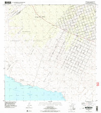
1995 Map of Pohue Bay
USGS Topo · Published 2000About this map
The boundary between the South Kona and Kau districts divides this coastal landscape, where the volcanic history of Hawaii is strikingly visible. The terrain is defined by expansive geological features such as the Lava Flow of 1887 and the Lava Flow of 1907, which have shaped the movement of settlement and infrastructure. While the Manuka Natural Area Reserve and Manuka State Park preserve the native environment in the northwest, the northeastern portion of the map shows an extensive, geometric network of residential roads like Aloha Boulevard and Ocean View Boulevard. This grid contrasts sharply with the nearby Manuka Mauka House (Site) and older named points such as Kanakaloloa. Along the shoreline, isolated water sources like the Kanonone Waterhole near Pohue Bay highlight the historical necessity of fresh water in an arid volcanic field.
Find a feature on this map
85 named features on this map. Tap any name to fly to it.
Don’t see what you’re looking for? This feature index may not catch every label — zoom into the map to look around manually.
Map Details
Editions of this 1995 Pohue Bay Map
This is the sole edition of this map. No revisions or reprints were ever made.
Other maps of this area

1924 · Kalae
USGS Topo · 1:62,500

1924 · Honuapo
USGS Topo · 1:62,500

1928 · Hoopuloa
USGS Topo · 1:62,500

1954 · Hawaii South
USGS Topo · 1:250,000

1959 · Hawaii South
USGS Topo · 1:250,000

1961 · Hawaii South
USGS Topo · 1:250,000

1962 · Hawaii South
USGS Topo · 1:250,000

1962 · Milolii
USGS Topo · 1:24,000

1962 · Puu Hou
USGS Topo · 1:24,000

1962 · Kahuku Ranch
USGS Topo · 1:24,000