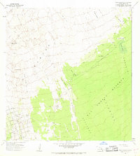
1967 Map of Puu O Keokeo
USGS Topo · Published 1968About this map
Lava Flow of 1926 and other historical volcanic events define the landscape of this southern Hawaii region, where the terrain transitions from the scorched earth of Kahuku to the dense greenery of the Kau Forest Reserve. This 1967 survey captures a moment of emerging development in the southwest, where a grid of new roads like Kailua Blvd and Ocean View Drive begins to intersect the older lava fields of 1887 and 1907.
Find a feature on this map
40 named features on this map. Tap any name to fly to it.
Don’t see what you’re looking for? This feature index may not catch every label — zoom into the map to look around manually.
Map Details
Editions of this 1967 Puu O Keokeo Map
This is the sole edition of this map. No revisions or reprints were ever made.
Other maps of this area

1924 · Honuapo
USGS Topo · 1:62,500

1928 · Mauna Loa
USGS Topo · 1:62,500

1928 · Hoopuloa
USGS Topo · 1:62,500

1954 · Hawaii South
USGS Topo · 1:250,000

1959 · Hawaii South
USGS Topo · 1:250,000

1961 · Hawaii South
USGS Topo · 1:250,000

1962 · Hawaii South
USGS Topo · 1:250,000

1962 · Kahuku Ranch
USGS Topo · 1:24,000

1962 · Pohue Bay
USGS Topo · 1:24,000

1962 · Papa
USGS Topo · 1:24,000