1960s Maps of Akupu, Hawaii
Explore 4 historic maps of Akupu from the 1960s. These maps offer a rare glimpse into what life looked like during the 1960s — showing old roads, neighborhoods, homes, and landmarks that have changed or disappeared over time.
Whether you're researching your family's past, planning a metal detecting trip, or studying how Akupu's landscape evolved across the 1960s, these high-resolution maps are a powerful tool for exploring the history of this region.
- Focus on a specific era: All maps on this page are from the 1960s, giving you a focused view of this time period.
- See what’s changed: Compare century-old streets, trails, and buildings to today's modern landscape using overlays and satellite layers.
- Research with precision: Use these maps for genealogy, historical research, land use analysis, or educational projects.
- View, download, or print: Maps are fully viewable online in high resolution, and can be downloaded or printed for your own records.
Start exploring Akupu's history through authentic maps from the 1960s. This is your window into the past.
Akupu, HI maps
(4)- 1960 Map of Schofield Barracks, 1962 Print
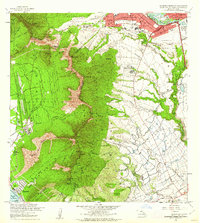 1960 Schofield Barracks1962 Print · USGSCentral Oahu and the Waianae Range are captured here during a period of significant military and agricultural activity. Researchers can trace the layout of Schofield Barracks, locate Kunia Camp, and find landmarks like Wheeler Field and Kolekole Pass.
 - 1961 Map of Oahu
 1961 Oahu1961 Print · USGSOahu's strategic landscape is captured here during the early statehood era, showing the balance between burgeoning urban centers and massive military installations. Trace the path of the Oahu Railway and Land Co or locate historical sites like Schofield Barracks and Punchbowl Hill.
 - 1965 Map of Oahu
 1965 Oahu1965 Print · USGSOahu in the mid-sixties reveals a landscape defined by significant military installations and growing coastal communities. Researchers can trace the infrastructure of Pearl Harbor, Schofield Barracks, and landmarks like Diamond Head.2 unique versions available
 - 1967 Map of Schofield Barracks, 1968 Print
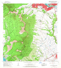 1967 Schofield Barracks1968 Print · USGSCentral Oahu in the late sixties shows a landscape shaped by military expansion and topographic extremes. Genealogists and historians can trace the footprints of Schofield Barracks, the homes at Kunia Camp, and the historic Kolekole Pass.
End of results
Showing maps 1-4 of 4
Top cities near Akupu
- Honolulu historical maps
- Waipahu historical maps
- Mililani historical maps
- Pearl City historical maps
- Kapolei historical maps
- Aiea historical maps
See more
Frequently asked questions
- What are the different types of historical maps available for Akupu?
- What is the oldest map of Akupu?
- Where can I purchase historical maps of Akupu for my home or office?
- Where can I download high-res historical maps of Akupu?
- Are there historical topographic maps available for Akupu?
- Is there historical aerial imagery available for Akupu?
- Where are historical maps of Akupu sourced from?