
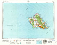
1965 Map of Oahu
USGS Topo · Published 1965About this map
Honolulu and its surrounding coastal settlements dominate this mid-century portrait of the island, which is characterized by a significant military footprint. Large federal holdings like Schofield Barracks Military Reservation and the Lualualei Naval Ammunition Depot occupy the interior and western shores, while the logistics of Pearl Harbor and Honolulu International Airport define the southern coastline. The island's topography is clearly delineated, from the heights of Nuuanu Pali and Puu Lanihuli to the volcanic profiles of Diamond Head and Koko Crater.
Find a feature on this map
101 named features on this map. Tap any name to fly to it.
Don’t see what you’re looking for? This feature index may not catch every label — zoom into the map to look around manually.
Map Details
Editions of this 1965 Oahu Map
2 editions found
Other maps of this area

1952 · Waimea
USGS Topo · 1:24,000

1952 · Koko Head
USGS Topo · 1:24,000

1952 · Mokapu
USGS Topo · 1:24,000

1953 · Haleiwa
USGS Topo · 1:24,000

1953 · Schofield Barracks
USGS Topo · 1:24,000

1953 · Honolulu
USGS Topo · 1:24,000

1953 · Ewa
USGS Topo · 1:24,000

1953 · Puuloa
USGS Topo · 1:24,000

1953 · Hauula
USGS Topo · 1:24,000

1954 · Oahu
USGS Topo · 1:250,000