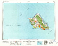
1965 Map of Oahu
USGS Topo · Published 1965About this map
Oahu is depicted here during a period of significant mid-century expansion, dominated by a heavy military presence and the burgeoning urbanization of Honolulu. The island's geography is defined by its dramatic volcanic landmarks, from the iconic Diamond Head and Koko Crater on the southeastern coast to the heights of Mt Kaala in the Waianae Range. The strategic importance of the island is evident in the sprawling installations at Pearl Harbor, Hickam Air Force Base, and Schofield Barracks. Inland, the map reveals the transitional state of the landscape, where massive forest reserves like the Pupukea-Paumalu Forest Reserve meet growing residential hubs in Waipahu and Pearl City. Transportation networks are shown in a state of modernization, including the early routes of H-1 and H-2 and the Keehi Lagoon Seadrome, reflecting the island's role as a critical Pacific crossroads.
Find a feature on this map
98 named features on this map. Tap any name to fly to it.
Don’t see what you’re looking for? This feature index may not catch every label — zoom into the map to look around manually.
Map Details
Editions of this 1965 Oahu Map
2 editions found

Other maps of this area

1952 · Waimea
USGS Topo · 1:24,000

1952 · Koko Head
USGS Topo · 1:24,000

1952 · Mokapu
USGS Topo · 1:24,000

1953 · Haleiwa
USGS Topo · 1:24,000

1953 · Schofield Barracks
USGS Topo · 1:24,000

1953 · Honolulu
USGS Topo · 1:24,000

1953 · Ewa
USGS Topo · 1:24,000

1953 · Puuloa
USGS Topo · 1:24,000

1953 · Hauula
USGS Topo · 1:24,000

1954 · Oahu
USGS Topo · 1:250,000