1990s Maps of Kauai County, Hawaii
Explore 7 historic maps of Kauai County from the 1990s. These maps offer a rare glimpse into what life looked like during the 1990s — showing old roads, neighborhoods, homes, and landmarks that have changed or disappeared over time.
Whether you're researching your family's past, planning a metal detecting trip, or studying how Kauai County's landscape evolved across the 1990s, these high-resolution maps are a powerful tool for exploring the history of this region.
- Focus on a specific era: All maps on this page are from the 1990s, giving you a focused view of this time period.
- See what’s changed: Compare century-old streets, trails, and buildings to today's modern landscape using overlays and satellite layers.
- Research with precision: Use these maps for genealogy, historical research, land use analysis, or educational projects.
- View, download, or print: Maps are fully viewable online in high resolution, and can be downloaded or printed for your own records.
Start exploring Kauai County's history through authentic maps from the 1990s. This is your window into the past.
Kauai County, HI maps
(7)- 1991 Map of Waialeale, 2003 Print
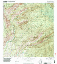
 1991 Waialeale2003 Print · USGSKauai's high interior peaks and vital watersheds are documented here during the early 1990s. Researchers can trace the island's water management history through several Rain Gages, the Upper Powerhouse, and falls like Uhau Iole Falls.
 - 1991 Map of Makaha Point, 2003 Print
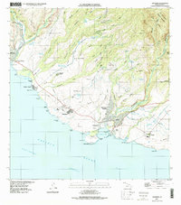
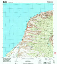 1991 Makaha Point2003 Print · USGSThe northwestern coast of Kauai shows a unique mix of military technology and wild terrain in the early nineties. Researchers can trace the footprint of the Pacific Missile Range Facility or locate landmarks like the Pu'uhonua Lookout and Pahole Spring.
 - 1991 Map of Waimea Canyon, 2003 Print
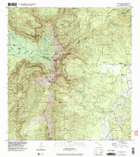
 1991 Waimea Canyon2003 Print · USGSKauai's interior highlands and deep canyon systems are preserved here in the early nineties, showing a landscape of protected reserves and remote mountain camps. Researchers can trace the network of wilderness outposts including Lonernea Camp and Wiliwili Camp, alongside landmarks like Waipoo Falls.
 - 1996 Map of Anahola, 1998 Print
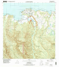
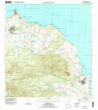 1996 Anahola1998 Print · USGSThe northern shore of Kauai in the late twentieth century shows a landscape of deep-rooted land divisions and vital water systems. Genealogists and researchers can trace family lands in Anahola and the Hawaiian Homesteads or locate landmarks like Kilauea Point Light Station.
 - 1996 Map of Hanapepe, 1998 Print
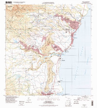
 1996 Hanapepe1998 Print · USGSThe southern coast of Kauai comes alive in the mid-nineties, showing a landscape of deep valleys and sugar-era infrastructure. Genealogists and historians can trace residential patterns in Hanapepe Heights or locate landmarks like the Baldwin Monument and Makaweli Landing.
 - 1996 Map of Hanalei, 1998 Print
 1996 Hanalei1998 Print · USGSThe northern coast of Kauai in the late nineties shows a landscape defined by the Hanalei River valley and its surrounding forest reserves. Genealogists and researchers can trace local landmarks from Princeville and Hanapai to the Hanalei Landing and Hanalei Pavilion.
 - 1996 Map of Kapaa, 1998 Print
 1996 Kapaa1998 Print · USGSEastern Kauai at the close of the twentieth century shows a vibrant mix of coastal settlements and mountain forest reserves. Genealogists and historians can locate Kauai Memorial Gardens, the Hanamaulu Airstrip, and local landmarks like the Sleeping Giant.
End of results
Showing maps 1-7 of 7
Top cities of Kauai County
Frequently asked questions
- What are the different types of historical maps available for Kauai County?
- What is the oldest map of Kauai County?
- Where can I purchase historical maps of Kauai County for my home or office?
- Where can I download high-res historical maps of Kauai County?
- Are there historical topographic maps available for Kauai County?
- Is there historical aerial imagery available for Kauai County?
- Where are historical maps of Kauai County sourced from?