1980s Maps of Kauai County, Hawaii
Explore 18 historic maps of Kauai County from the 1980s. These maps offer a rare glimpse into what life looked like during the 1980s — showing old roads, neighborhoods, homes, and landmarks that have changed or disappeared over time.
Whether you're researching your family's past, planning a metal detecting trip, or studying how Kauai County's landscape evolved across the 1980s, these high-resolution maps are a powerful tool for exploring the history of this region.
- Focus on a specific era: All maps on this page are from the 1980s, giving you a focused view of this time period.
- See what’s changed: Compare century-old streets, trails, and buildings to today's modern landscape using overlays and satellite layers.
- Research with precision: Use these maps for genealogy, historical research, land use analysis, or educational projects.
- View, download, or print: Maps are fully viewable online in high resolution, and can be downloaded or printed for your own records.
Start exploring Kauai County's history through authentic maps from the 1980s. This is your window into the past.
Kauai County, HI maps
(18)- 1983 Map of Hanalei
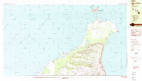
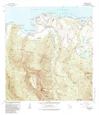 1983 Hanalei1983 Print · USGSKauai's North Shore is captured here in the early eighties, showing the development of Princeville alongside traditional agricultural areas. Researchers can trace the water networks and legacy land divisions of Hanalei Homesteads and the National Wildlife Refuge.
 - 1983 Map of Haena
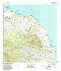
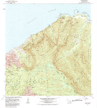 1983 Haena1983 Print · USGSThe North Shore of Kauai is captured here in the early eighties, from the coastal caves of Haena to the high ALAKAI SWAMP. Trace cultural landmarks like the Ka Ulu a Paoa Heiau and the remote Kokee Air Force Station.
 - 1983 Map of Waialeale, 1984 Print
 1983 Waialeale1984 Print · USGSThe high interior of Kauai is captured here in the early eighties, showing the critical watershed surrounding the peaks of Waialeale and Kawaikini. Researchers can trace the development of island water infrastructure through labels for the Upper Powerhouse, the Stable Ditch Trail, and the Kilohana Crater.2 unique versions available
 - 1983 Map of Anahola, 1984 Print
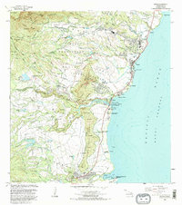
 1983 Anahola1984 Print · USGSKauai's northeast coast in the early eighties shows a landscape of vital water infrastructure and agricultural heritage. Researchers can trace the Koolau Ditch system, locate the Kapinao Heiau, and explore the settled Hawaiian Homes tracts near Anahola.
 - 1983 Map of Koloa, 1984 Print
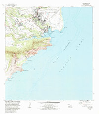
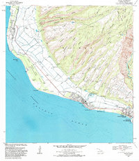
 1983 Koloa1984 Print · USGSThe southern coast of Kauai comes alive in the early eighties, showing the agricultural and coastal development of the islands. Researchers can trace the Old Railroad Grade and locate historic sites like Koloa Mill, Hoai Heiau, and Koloa Cemetery.2 unique versions available
 - 1983 Map of Lihue, 1984 Print
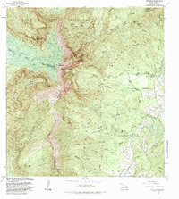
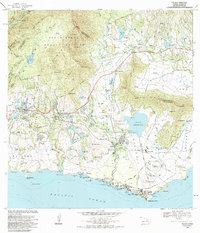
 1983 Lihue1984 Print · USGSKauai’s primary commercial and transit hub comes into focus in the early eighties as the island’s infrastructure expanded around the bay. Genealogists and researchers can trace local institutions like Immaculate Conception Sch or find coastal landmarks from Nawiliwili to the ancient Menehune Fishpond.
 - 1983 Map of Hanapepe, 1984 Print
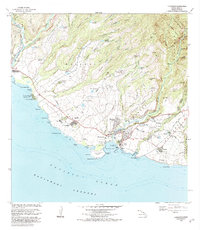 1983 Hanapepe1984 Print · USGSSouthwestern Kauai is shown here in the early eighties as a landscape of historic forts, plantation villages, and coastal commerce. Researchers can trace the layout of Russian Fort Elizabeth State Hist Park, the Sugar Mill at Numila, and Pakala Village.2 unique versions available
 - 1983 Map of Makaha Point, 1984 Print
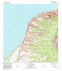 1983 Makaha Point1984 Print · USGSThe western coast of Kauai in the early eighties shows a unique intersection of high-tech defense and protected wilderness. Local researchers can trace the coastal site of Saki Mana or locate ancient Heiau landmarks and remote springs like Pohakuloa Spring.2 unique versions available
 - 1983 Map of Kapaa, 1984 Print
 1983 Kapaa1984 Print · USGSThe eastern coast of Kauai appears in the early eighties as a landscape where ancient Hawaiian heritage meets modern island life. Genealogists and researchers can trace local landmarks like Poliahu Heiau, the Old Railroad Grade, and the Wailua Falls.2 unique versions available
 - 1983 Map of Kekaha, 1984 Print
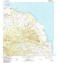
 1983 Kekaha1984 Print · USGSThe western coast of Kauai was a landscape of military activity and irrigation engineering in the early eighties. Genealogists and researchers can trace the neighborhoods of Kekaha and Waimea, locating landmarks like St Theresa Sch and Kikiaola Harbor.
 - 1983 Map of Waimea Canyon, 1984 Print
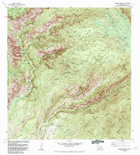 1983 Waimea Canyon1984 Print · USGSKauai’s interior highlands in the early eighties were a hub of water engineering and remote forest management. You can trace the path of the Kekaha Ditch and Olokele Ditch or locate backcountry outposts like Lonomea Camp and Walaalae Cabin.
 - 1984 Map of Niihau South
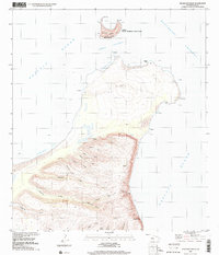
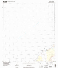
 1984 Niihau South1984 Print · USGSSouthern Niihau in the mid-1980s reveals a unique landscape of intermittent drainage and significant interior water bodies. Genealogists and researchers can trace local landmarks like Kiekie, Poonoone Caves, and the isolated islet of Kaula.
 - 1984 Map of Niihau North
 1984 Niihau North1984 Print · USGSNiihau's secluded northern landscape and the primary settlement of Puuwai are documented here in the mid-eighties. Researchers can trace the island's ranching infrastructure through features like the Stock Pond and the peaks of Paniau and Kaeo.2 unique versions available
 - 1984 Map of Anahola, 1986 Print
 1984 Anahola1986 Print · USGSThe windward coast of Kauai is captured here in the mid-eighties, showing the intersection of traditional Hawaiian land divisions and modern infrastructure. Genealogists and historians can trace the foundations of Kilauea and Anahola, find the Kilauea Sch, and locate cultural sites like Kapinao Heiau.
 - 1989 Map of Halalii Lake, 2001 Print
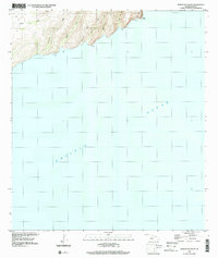
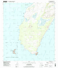 1989 Halalii Lake2001 Print · USGSNiihau’s coastline and interior basins are captured here in the late 1980s, centered on the settlements of Pu'uwai and Nonopapa. Genealogists and researchers can trace local landmarks like Halalii Lake, the State Seabird Sanctuary, and isolated Ka'ula island.
 - 1989 Map of Keanauhi Valley, 2001 Print
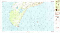
 1989 Keanauhi Valley2001 Print · USGSKauai's northern coast and the island of Lehua are shown in the late twentieth century, characterized by natural sanctuaries and rugged coastal valleys. Researchers can trace the layout of the Lehua State Seabird Sanctuary and remote terrain names like Keanauhi Valley and Pōleho.
 - 1989 Map of Honuaula Valley, 2001 Print
 1989 Honuaula Valley2001 Print · USGSThe Kauai coastline near the Waimea District is captured in its natural state during the late eighties. Researchers can trace the rugged drainage patterns of Honua'ula Valley, Kalaoa Valley, and the prominent Pueo Point.
 - 1989 Map of Kalanei, 2001 Print
 1989 Kalanei2001 Print · USGSNiihau's western coastline and the community of Pu'uwai are shown here as they appeared in the late twentieth century. Genealogists and researchers can trace local landmarks and settlements including Kalānei, Kālehu, and the waters of Lo'e Lake.
End of results
Showing maps 1-18 of 18
Top cities of Kauai County
Frequently asked questions
- What are the different types of historical maps available for Kauai County?
- What is the oldest map of Kauai County?
- Where can I purchase historical maps of Kauai County for my home or office?
- Where can I download high-res historical maps of Kauai County?
- Are there historical topographic maps available for Kauai County?
- Is there historical aerial imagery available for Kauai County?
- Where are historical maps of Kauai County sourced from?