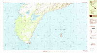
1984 Map of Niihau South
USGS Topo · Published 1984About this map
Halalii Lake and Halulu Lake dominate the arid interior of this southern island landscape, illustrating the unique hydrology of the Waimea District in the mid-1980s. While most drainage on this portion of the island is intermittent, the presence of Apana Reservoir and numerous smaller basins like Alieiki Lake and Nonopapa Lake reveal a managed approach to water in this dry environment. The coast is defined by geological features such as the Poonoone Caves near Olamoi and the prominent southern heights of Kawaihoa. An inset provides a detailed view of Kaula, an isolated volcanic islet with its own distinct rock shoals and cave systems. Small markers of modern infrastructure, such as the Radio Twr, appear alongside ancient place names like Mauuloa, Kiekie, and Kealea, showing the layer of human presence upon the shoreline and interior plains.
Find a feature on this map
31 named features on this map. Tap any name to fly to it.
Don’t see what you’re looking for? This feature index may not catch every label — zoom into the map to look around manually.
Map Details
Editions of this 1984 Niihau South Map
This is the sole edition of this map. No revisions or reprints were ever made.
Other maps of this area

1954 · Kauai
USGS Topo · 1:250,000

1967 · Kauai
USGS Topo · 1:250,000

1970 · Kauai
USGS Topo · 1:250,000
1984 · Niihau North
USGS Topo · 1:25,000
1989 · Halalii Lake
USGS Topo · 1:24,000
1989 · Keanauhi Valley
USGS Topo · 1:24,000
1989 · Honuaula Valley
USGS Topo · 1:24,000
1989 · Kalanei
USGS Topo · 1:24,000

2013 · Niihau South OE W
USGS Topo · 1:24,000
2013 · Niihau South
USGS Topo · 1:24,000