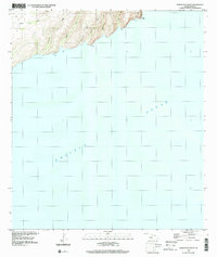
1989 Map of Honuaula Valley
USGS Topo · Published 2001About this map
Honua'ula Valley and a series of dramatic coastal drainages define this stretch of the Kauai shoreline, recorded here based on 1989 aerial imagery. The landscape is dominated by steep, parallel valleys including Apana Valley, Kalaoa Valley, and Hanakamapene Valley, which terminate abruptly at the edge of the Pacific Ocean. This survey highlights the natural geography of the Waimea District, showing where the land transitions from high ridges to the sea at landmarks like Pueo Point. Free of major man-made structures or cultural changes at the time of the photo-inspection, the map preserves the prehistoric character of the terrain, detailing the numerous rocks and drainage patterns of Nemilu Valley and Awawaloa Valley.
Find a feature on this map
11 named features on this map. Tap any name to fly to it.
Don’t see what you’re looking for? This feature index may not catch every label — zoom into the map to look around manually.
Map Details
Editions of this 1989 Honuaula Valley Map
This is the sole edition of this map. No revisions or reprints were ever made.
Other maps of this area

1954 · Kauai
USGS Topo · 1:250,000

1967 · Kauai
USGS Topo · 1:250,000

1970 · Kauai
USGS Topo · 1:250,000
1984 · Niihau South
USGS Topo · 1:25,000
1984 · Niihau North
USGS Topo · 1:25,000
1989 · Halalii Lake
USGS Topo · 1:24,000
1989 · Keanauhi Valley
USGS Topo · 1:24,000
1989 · Kalanei
USGS Topo · 1:24,000
2013 · Niihau South
USGS Topo · 1:24,000
2013 · Niihau North OE W
USGS Topo · 1:24,000