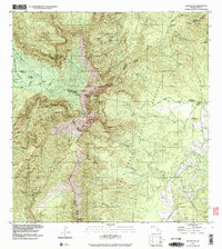
1991 Map of Waialeale
USGS Topo · Published 2003About this map
Waialeale and the peak of Kawaikini crown this high-altitude landscape on Kauai, where the headwaters of several major river systems diverge. The survey illustrates a complex hydrologic network including the Wainiha River flowing north and the North Fork Wailua River pushing east. Infrastructure for water management and power is evident at the Upper Powerhouse and the associated Upper Powerhouse Dam. The terrain is defined by deep incisions such as Makaveli Canyon and Olokele Canyon, while numerous Rain Gages and Gaging Stations across the Halelea Forest Reserve and Alakai Wilderness Preserve signal the area's significance as a primary watershed. To the southeast, the geography transitions toward the Kilohana Crater, showing the early 1990s extent of the Lihue-Koloa Forest Reserve and the small settlement at Kapalaoa.
Find a feature on this map
67 named features on this map. Tap any name to fly to it.
Don’t see what you’re looking for? This feature index may not catch every label — zoom into the map to look around manually.
Map Details
Editions of this 1991 Waialeale Map
This is the sole edition of this map. No revisions or reprints were ever made.
Other maps of this area

1954 · Kauai
USGS Topo · 1:250,000

1963 · Anahola
USGS Topo · 1:24,000

1963 · Lihue
USGS Topo · 1:24,000

1963 · Hanapepe
USGS Topo · 1:24,000

1963 · Kapaa
USGS Topo · 1:24,000

1963 · Koloa
USGS Topo · 1:24,000

1963 · Hanalei
USGS Topo · 1:24,000

1965 · Waimea Canyon
USGS Topo · 1:24,000

1965 · Haena
USGS Topo · 1:24,000

1965 · Waialeale
USGS Topo · 1:24,000