
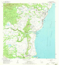
1963 Map of Kapaa
USGS Topo · Published 1965About this map
Ancient Hawaiian cultural sites and modern development meet along the eastern coast of Kauai in this early 1960s record. Significant archaeological landmarks are noted near the mouth of the Wailua River, including the City of Refuge-Hikina o ka la Heiau, Malae Heiau, and Poliahu Heiau. These sacred locations neighbor growing residential clusters like Wailua House Lots and the town of Kapaa. The landscape rises from the Pacific Ocean toward the Makaleha Mountains, punctuated by the distinctive silhouette of the Sleeping Giant on Nonou mountain. Inland, the map documents the expansive Kapaa Homesteads and Wailua Homesteads, revealing a complex system of water management with the Kapahi Ditch and numerous reservoirs like Kapaia Reservoir supporting the upland agriculture. From the tourism-focused Fern Grotto to the industrial Ahukini Landing, the survey captures the island's mid-century shift between traditional land use and a modernizing economy.
Find a feature on this map
87 named features on this map. Tap any name to fly to it.
Don’t see what you’re looking for? This feature index may not catch every label — zoom into the map to look around manually.
Map Details
Editions of this 1963 Kapaa Map
2 editions found
Other maps of this area

1954 · Kauai
USGS Topo · 1:250,000

1963 · Anahola
USGS Topo · 1:24,000

1963 · Lihue
USGS Topo · 1:24,000

1963 · Koloa
USGS Topo · 1:24,000

1963 · Hanalei
USGS Topo · 1:24,000

1965 · Waialeale
USGS Topo · 1:24,000

1967 · Kauai
USGS Topo · 1:250,000

1970 · Kauai
USGS Topo · 1:250,000

1978 · Kapaa
USGS Topo · 1:24,000
1978 · Lihue
USGS Topo · 1:24,000