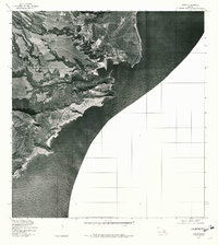
1978 Map of Lihue
USGS Topo · Published 1981About this map
Lihue occupies the heart of this orthophotoquad, which uses aerial photography from early 1978 to show the landscape of Kauai's southeast coast. The imagery provides a clear view of the agricultural patterns and early residential expansion around the settlement, where fields and roads meet the shoreline. To the south, the winding course of Huleia Stream carves through the coastal terrain before reaching the sea. The jagged coastline is defined by prominent landmarks such as Ninini Point near the harbor entrance and the more distant Kawelikoa Point further south along the Pacific Ocean. This photographic survey captures the island's transition between its traditional agricultural roots and modern development, documenting the exact layout of plantation lands and coastal infrastructure during the late seventies.
Find a feature on this map
5 named features on this map. Tap any name to fly to it.
Don’t see what you’re looking for? This feature index may not catch every label — zoom into the map to look around manually.
Map Details
Editions of this 1978 Lihue Map
This is the sole edition of this map. No revisions or reprints were ever made.
Other maps of this area

1954 · Kauai
USGS Topo · 1:250,000

1963 · Lihue
USGS Topo · 1:24,000

1963 · Kapaa
USGS Topo · 1:24,000

1963 · Koloa
USGS Topo · 1:24,000

1965 · Waialeale
USGS Topo · 1:24,000

1967 · Kauai
USGS Topo · 1:250,000

1970 · Kauai
USGS Topo · 1:250,000

1978 · Kapaa
USGS Topo · 1:24,000
1978 · Koloa
USGS Topo · 1:24,000
1983 · Waialeale
USGS Topo · 1:24,000