
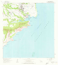
1963 Map of Lihue
USGS Topo · Published 1964About this map
Lihue serves as the focal point of this mid-century Kauai survey, anchored by institutional landmarks such as the Wilcox Memorial Hospital and the Immaculate Conception Ch. The town's educational infrastructure is well-defined, featuring the Wilcox Sch, Lihue High Sch, and Kauai High Sch. Along the coast, the Nawiliwili Light Station stands at Ninini Point, guarding the entrance to Nawiliwili Bay where the Nawiliwili Stream meets the sea.
Find a feature on this map
64 named features on this map. Tap any name to fly to it.
Don’t see what you’re looking for? This feature index may not catch every label — zoom into the map to look around manually.
Map Details
Editions of this 1963 Lihue Map
2 editions found
Other maps of this area

1954 · Kauai
USGS Topo · 1:250,000

1963 · Kapaa
USGS Topo · 1:24,000

1963 · Koloa
USGS Topo · 1:24,000

1965 · Waialeale
USGS Topo · 1:24,000

1967 · Kauai
USGS Topo · 1:250,000

1970 · Kauai
USGS Topo · 1:250,000

1978 · Kapaa
USGS Topo · 1:24,000
1978 · Lihue
USGS Topo · 1:24,000
1978 · Koloa
USGS Topo · 1:24,000
1983 · Waialeale
USGS Topo · 1:24,000