1960s Maps of Ada County, Idaho
Explore 4 historic maps of Ada County from the 1960s. These maps offer a rare glimpse into what life looked like during the 1960s — showing old roads, neighborhoods, homes, and landmarks that have changed or disappeared over time.
Whether you're researching your family's past, planning a metal detecting trip, or studying how Ada County's landscape evolved across the 1960s, these high-resolution maps are a powerful tool for exploring the history of this region.
- Focus on a specific era: All maps on this page are from the 1960s, giving you a focused view of this time period.
- See what’s changed: Compare century-old streets, trails, and buildings to today's modern landscape using overlays and satellite layers.
- Research with precision: Use these maps for genealogy, historical research, land use analysis, or educational projects.
- View, download, or print: Maps are fully viewable online in high resolution, and can be downloaded or printed for your own records.
Start exploring Ada County's history through authentic maps from the 1960s. This is your window into the past.
Ada County, ID maps
(4)- 1960 Map of Mayfield, 1962 Print
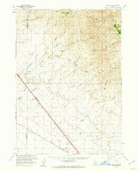 1960 Mayfield1962 Print · USGSElmore County's ranching and rail landscape is preserved here during the early sixties, showing the transition from the high desert to the national forest. Researchers can locate the Regina (Site) and trace the Union Pacific railroad past historic sites like Seven L Ranch and the local cemetery.3 unique versions available
 - 1962 Map of Boise
 1962 Boise1962 Print · USGSThe Treasure Valley at the start of the sixties reveals a landscape of expanding towns and complex irrigation networks along the Snake River. Genealogists and historians can trace the foundations of modern Idaho through markers like Initial Point, the mining history of Silver City, and the early infrastructure of Lucky Peak Dam.
 - 1962 Map of Hailey
 1962 Hailey1962 Print · USGSCentral Idaho in the early sixties showcases a landscape of high-altitude ranching and mining at the foot of the Sawtooth Mountains. Genealogists and historians can trace the rail-and-river economy through the Union Pacific Railroad corridor and explore old mining sites like the Triumph Mine or Silver Star Queens Mine.
 - 1969 Map of Arrowrock Dam, 1972 Print
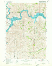 1969 Arrowrock Dam1972 Print · USGSThe Boise River canyon in the late 1960s was a hub of water management and high-desert recreation. You can trace the shorelines of Arrowrock Reservoir, locate the Arrowrock Dam, and find family-named landmarks like Browns Gulch or Sams Gulch.2 unique versions available
End of results
Showing maps 1-4 of 4
Top cities of Ada County
- Boise historical maps
- Meridian historical maps
- Eagle historical maps
- Kuna historical maps
- Star historical maps
- Garden City historical maps
See more
Frequently asked questions
- What are the different types of historical maps available for Ada County?
- What is the oldest map of Ada County?
- Where can I purchase historical maps of Ada County for my home or office?
- Where can I download high-res historical maps of Ada County?
- Are there historical topographic maps available for Ada County?
- Is there historical aerial imagery available for Ada County?
- Where are historical maps of Ada County sourced from?