1970s Maps of Ada County, Idaho
Explore 5 historic maps of Ada County from the 1970s. These maps offer a rare glimpse into what life looked like during the 1970s — showing old roads, neighborhoods, homes, and landmarks that have changed or disappeared over time.
Whether you're researching your family's past, planning a metal detecting trip, or studying how Ada County's landscape evolved across the 1970s, these high-resolution maps are a powerful tool for exploring the history of this region.
- Focus on a specific era: All maps on this page are from the 1970s, giving you a focused view of this time period.
- See what’s changed: Compare century-old streets, trails, and buildings to today's modern landscape using overlays and satellite layers.
- Research with precision: Use these maps for genealogy, historical research, land use analysis, or educational projects.
- View, download, or print: Maps are fully viewable online in high resolution, and can be downloaded or printed for your own records.
Start exploring Ada County's history through authentic maps from the 1970s. This is your window into the past.
Ada County, ID maps
(5)- 1970 Map of Southwest Emmett, 1973 Print
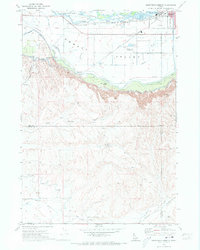 1970 Southwest Emmett1973 Print · USGSThe Emmett Valley was a complex landscape of irrigation and industry in the early seventies, defined by the Payette River and its many canals. Researchers can trace rural school districts like Vanderdasson School or locate the historic Del Monte and Cold House sites along the Union Pacific tracks.
 - 1972 Map of Boise North, 1975 Print
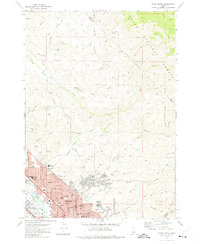 1972 Boise North1975 Print · USGSBoise and Garden City expand into the Idaho foothills during the early seventies, showing a growing urban grid meeting the national forest. Researchers can trace neighborhood development and local history through landmarks like Lowell Sch, the Old Military Reservation, and Stewart Gulch.3 unique versions available
 - 1972 Map of Lucky Peak, 1975 Print
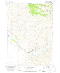 1972 Lucky Peak1975 Print · USGSThe Boise River valley and the slopes of Shaw Mountain were centers of mining and water engineering in the 1970s. Researchers can trace the Oregon Trail, locate old diggings at the Adelmann Mine, and explore the infrastructure of the Lucky Peak Dam.
 - 1972 Map of Robie Creek, 1975 Print
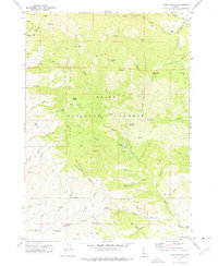 1972 Robie Creek1975 Print · USGSThe Boise Front was a rugged crossroads of mining and recreation in the early seventies, where jeep trails and pack routes crisscrossed the high ridges. Modern researchers can trace the locations of the Bumblebee Mine, Davidson Ranch, and historic mountain crossings like Aldape Summit.2 unique versions available
 - 1972 Map of Boise South, 1976 Print
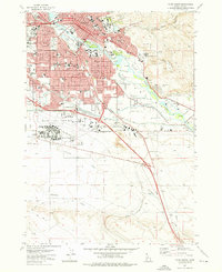 1972 Boise South1976 Print · USGSBoise and the surrounding Idaho plains are captured during a decade of rapid modernization and civic growth. Researchers can trace the mid-century layout of Boise State College or locate the historic Military Cem and the State Penitentiary.4 unique versions available
End of results
Showing maps 1-5 of 5
Top cities of Ada County
- Boise historical maps
- Meridian historical maps
- Eagle historical maps
- Kuna historical maps
- Star historical maps
- Garden City historical maps
See more
Frequently asked questions
- What are the different types of historical maps available for Ada County?
- What is the oldest map of Ada County?
- Where can I purchase historical maps of Ada County for my home or office?
- Where can I download high-res historical maps of Ada County?
- Are there historical topographic maps available for Ada County?
- Is there historical aerial imagery available for Ada County?
- Where are historical maps of Ada County sourced from?